Unveiling the Unseen: Navigating the Caribbean Through Ancient Taino Territory Maps
Forget the typical resort brochure. Beyond the shimmering turquoise waters and powdery white sands lies a Caribbean that few travelers truly discover – a landscape etched with the stories, cosmology, and territorial understanding of its original inhabitants: the Taino. This isn’t about GPS coordinates or modern political boundaries; it’s about navigating the islands through the ancient "maps" drawn not on parchment, but in the very land, the stars, and the sacred geometry of ceremonial plazas. For the discerning traveler seeking depth and genuine cultural immersion, exploring the Caribbean through the lens of Taino territory maps offers an unparalleled journey into the soul of these islands.
Our "location" for review isn’t a single museum or archaeological site, but the entire Taino-mapped Caribbean, with specific sites serving as pivotal points on this ancient, living atlas. It’s a concept, a perspective, a way of seeing the islands that transcends the colonial overlay and reconnects us with the profound indigenous understanding of place.
The Taino Worldview: Territory Beyond Borders

To understand Taino territory maps, we must first shed our Eurocentric notions of cartography. For the Taino, territory wasn’t about lines on a paper or fences in the ground. It was an intricate web of relationships: between communities, between humans and the natural world, and between the living and the spirit realm. Their "maps" were oral traditions, star charts, petroglyphs marking sacred sites, and the very layout of their villages and ceremonial centers (bateyes). These weren’t static blueprints but dynamic guides to resource management, spiritual pilgrimage, trade routes, and ancestral connections.
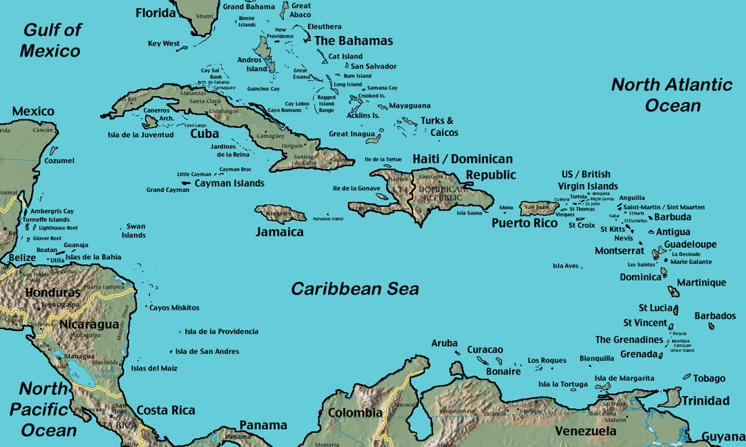
Each island, or group of islands, had its own Taino name – Ayiti/Quisqueya (Hispaniola), Borikén (Puerto Rico), Cubanas (Cuba), Xaymaca (Jamaica), Lucayan Islands (Bahamas) – reflecting a deep, personal relationship with the land. Within these larger territories, powerful cacicazgos (chiefdoms) held sway, their boundaries often defined by natural features like rivers, mountain ranges, and coastlines, but more importantly, by cultural allegiances and the spiritual power associated with particular places.
Hispaniola (Ayiti/Quisqueya): The Heart of the Taino World
Our journey begins in Hispaniola, an island profoundly shaped by Taino civilization and, tragically, by its violent encounter with Columbus. Here, the Taino developed a complex societal structure, with five major cacicazgos: Marién, Maguá, Maguana, Jaragua, and Higüey. These chiefdoms weren’t just administrative divisions; they represented distinct cultural and spiritual spheres, each with its own cacique (chief), unique traditions, and sacred sites.

To "map" Hispaniola through Taino eyes is to understand the significance of its diverse ecosystems. The fertile Cibao Valley (Maguá) was prime agricultural land, teeming with yuca and maize. The coastal plains (Marién, Jaragua) were vital for fishing and trade. The rugged mountains (Maguana) held spiritual significance, often housing sacred caves and sources of precious stones.
Key Sites on the Taino Map of Hispaniola:
- Cueva de las Maravillas (Cave of Wonders), Dominican Republic: This stunning cave system, adorned with hundreds of well-preserved Taino petroglyphs and pictographs, acts as a visual encyclopedia of Taino cosmology and daily life. It’s a subterranean "map" of their spiritual journey, depicting deities (cemis), human figures, and animals. Exploring it offers a direct connection to the Taino mind, understanding how natural formations were imbued with profound meaning and served as sacred meeting places, effectively marking vital points on their territorial understanding.
- Parque Nacional del Este, Dominican Republic: Beyond its pristine beaches, this national park is home to numerous Taino cave systems, including the Cueva del Puente and Cueva de Berna. These caves reveal evidence of long-term Taino habitation and ceremony, highlighting the Taino’s intimate relationship with the island’s natural resources and their use of these hidden spaces for spiritual practices. Their placement along the coast and inland suggests a strategic territorial distribution for both sustenance and sanctuary.

Borikén (Puerto Rico): Island of the Valient Noble Lord
Moving east, Borikén, now Puerto Rico, offers perhaps the most tangible surviving "map" in the form of the Caguana Indigenous Ceremonial Center. This remarkable archaeological site in Utuado is not merely a collection of stones; it is a meticulously designed landscape that reflects the Taino understanding of their world, their cosmos, and their social order.
Caguana consists of ten ceremonial plazas (bateyes) of various sizes, bordered by carved stone monoliths. These plazas were used for ritual dances (areytos), ball games (batey), and important communal gatherings. The alignment of the plazas, their spatial relationships, and the iconography on the carved stones all serve as a sophisticated territorial and cosmological map.
- Sacred Geometry: The arrangement of the plazas often mirrors celestial alignments, connecting the earthly realm with the heavens. This suggests that the Taino understood their territory not just horizontally across the land, but vertically, encompassing the sky above and the underworld below.
- Social Hierarchy: The size and prominence of certain plazas likely indicated the social importance of the groups that gathered there, effectively mapping the social and political landscape of the local cacicazgo.
- Resource Management: Caguana’s location near fertile lands and a river would have made it a central point for communities, signifying a hub within a larger resource-rich territory.

Visiting Caguana is like stepping onto a three-dimensional map. You walk through the spaces where the Taino once gathered, played, and worshipped, gaining an intuitive understanding of how they organized their world and their place within it. Other sites like Tibes Indigenous Ceremonial Center further south offer similar insights, reinforcing the idea of these plazas as central nodes within their territorial networks.
Cuba (Cubanas): The Long Island’s Secrets
Cuba, the largest of the Greater Antilles, held a diverse Taino population, particularly in its eastern regions. While less widely publicized for Taino heritage than Hispaniola or Puerto Rico, Cuba’s landscapes are equally rich with indigenous echoes. The Taino here were adept navigators and fishermen, their territories often extending along the coastlines and into the fertile interior.
Key Sites on the Taino Map of Cuba:
- Punta del Este, Isle of Youth: This remarkable cave system boasts over 200 ancient pictographs, often referred to as the "Sistine Chapel of the Caribbean." These circular designs, sun motifs, and human figures are believed to represent a Taino calendar or astronomical observations, effectively mapping time and celestial movements, which were crucial for planting, harvesting, and understanding the rhythm of their territorial year.
- La Caridad de los Indios, Oriente Province: This archaeological site, along with others in eastern Cuba, provides evidence of extensive Taino villages and agricultural practices. The sheer scale of these settlements indicates a well-organized territorial strategy for food production and community living, often strategically located near fresh water sources and fertile valleys.
- Cueva de los Indios, Viñales Valley: While some petroglyphs here might be from later periods, the cave itself, with its underground river, highlights the Taino’s use of natural features as shelters, sacred spaces, and potentially strategic points within their territorial defense or resource gathering.
Exploring Cuba through a Taino lens means appreciating the subtle clues in its geography – the strategic placement of settlements near abundant fishing grounds, the significance of caves as spiritual sanctuaries, and the routes taken through dense forests and along rivers, which formed their invisible pathways and territorial markers.
Jamaica (Xaymaca) and the Lucayan Islands (Bahamas): Coastal Connections
Jamaica, known to the Taino as Xaymaca ("land of wood and water"), and the Lucayan Islands (modern Bahamas) offer a glimpse into the Taino’s mastery of maritime territories. These were people deeply connected to the sea, their canoes (canoas) serving as vital vessels for trade, communication, and exploration across vast stretches of ocean. Their "maps" here extended beyond land to include currents, star paths, and the knowledge of distant islands.
- Jamaica: Archaeological findings at sites like White Marl and Little River provide insights into Taino village life, often situated strategically along the coast or major rivers. These locations were chosen for access to marine resources, fresh water, and defensible positions, reflecting a clear territorial strategy. The Taino petroglyphs found in caves like Mountain River Cave further illustrate their spiritual connection to the land and its features.
- Lucayan Islands: The Lucayans, a Taino subgroup, were the first indigenous people encountered by Columbus. Their territories were a complex archipelago, requiring exceptional navigational skills. Sites like Preacher’s Cave on Eleuthera, a Taino burial and ceremonial site, underscore the spiritual significance of particular natural formations within their island territories. The distribution of Taino artifacts across various cays paints a picture of inter-island trade routes and a shared cultural sphere, essentially a "map" of their sea-faring domain.
The Modern Traveler’s Map: Responsible Exploration
Embarking on this journey to discover the Taino-mapped Caribbean is not just about visiting archaeological sites; it’s about shifting your perspective. It’s about recognizing the enduring legacy of the Taino in the landscape, the language (many Caribbean words like "hammock," "barbecue," "canoe" are Taino in origin), and the spirit of the islands.
To truly engage with this ancient map, consider these practices:
- Seek Local Guides: Whenever possible, engage local indigenous or knowledgeable guides. Their insights into the history, cosmology, and cultural significance of sites are invaluable.
- Respect the Land: Remember that these sites are sacred. Tread lightly, leave no trace, and do not disturb any artifacts or natural features.
- Support Indigenous Initiatives: Look for opportunities to support contemporary Taino cultural revitalization efforts, local artisans, and community-based tourism projects that honor indigenous heritage.
- Educate Yourself: Read up on Taino history and culture before and during your trip. The more you understand, the deeper your appreciation will be.
- Look Beyond the Obvious: While major sites are important, sometimes the most profound connections are found in the subtle details – a petroglyph on a rock face, the alignment of trees, or the flow of a river that once defined a territorial boundary.
Conclusion: Reclaiming the Caribbean’s True North
Exploring the Caribbean through the invisible, yet deeply felt, maps of the Taino is a transformative experience. It challenges the colonial narrative and invites travelers to connect with the islands on a much more profound level. It reveals a sophisticated civilization with a deep understanding of its environment, its cosmos, and its place within it.
This journey is not just a review of a location; it is an invitation to rediscover the Caribbean’s true North, guided by the wisdom of its first peoples. By understanding their territorial maps – drawn in the very fabric of the land – we not only honor their enduring legacy but also gain a richer, more meaningful appreciation for the vibrant, complex, and ancient soul of these magnificent islands. So, pack your bags, open your mind, and prepare to navigate a Caribbean you never knew existed.
