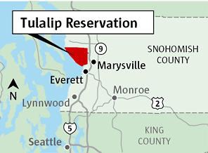
The lines etched onto a map of the Tulalip Tribes Reservation in Washington State are far more than mere geographical boundaries. They represent a profound narrative of resilience, cultural survival, and sovereign identity, woven over millennia. For those seeking to understand the true spirit of the Pacific Northwest, this map is an indispensable guide to a living history, offering a vital lens through which to view indigenous stewardship, treaty rights, and the vibrant contemporary life of the Tulalip people. This exploration delves into the historical foundations, cultural significance, and modern dynamism embodied by this unique territory, perfect for both the discerning traveler and the history enthusiast.
The Ancestral Tapestry: Before the Lines Were Drawn
Long before European contact and the imposition of colonial boundaries, the land now encompassing the Tulalip Reservation, and indeed vast stretches of the Puget Sound basin, was the ancestral home of numerous Coast Salish peoples. The Tulalip Tribes are a confederation of Snohomish, Snoqualmie, Skagit, Stillaguamish, Samish, and other allied bands who traditionally inhabited the river systems and saltwater shores of what is now Snohomish, Skagit, and King counties in Washington.
Their world was defined by an intimate and sustainable relationship with the land and sea. Salmon, cedar, and shellfish were the cornerstones of their economy and culture. Intricate knowledge of the tides, seasons, and animal migrations ensured their survival and prosperity. Longhouses, some stretching hundreds of feet, served as communal homes and cultural centers, hosting potlatches – elaborate ceremonies of feasting, gift-giving, and cultural exchange that reinforced social structures and celebrated life events. Canoes, carved from single cedar logs, were their highways, connecting communities across the intricate waterways of Puget Sound. This deep, spiritual connection to their homelands, their Lushootseed language, and their elaborate social and spiritual systems formed a rich and self-sufficient civilization.

The Treaty of Point Elliott (1855): A Map’s Genesis
The most pivotal event in shaping the Tulalip Tribes’ modern map was the Treaty of Point Elliott, signed on January 22, 1855. This was an era of rapid American expansion, driven by the ideology of Manifest Destiny and the pursuit of land and resources. Isaac Stevens, the first governor and superintendent of Indian Affairs for Washington Territory, orchestrated a series of treaties aimed at extinguishing Native title to vast tracts of land and confining indigenous peoples to reservations.
At Point Elliott (now Mukilteo), representatives from 22 tribes and bands, including Chief Seattle of the Suquamish and Duwamish, gathered. Under immense pressure and often misunderstanding the implications of the English legal framework, the tribal leaders ceded millions of acres of their ancestral lands to the United States. In return, the treaty established several reservations, including the "Snohomish, Snoqualmie, and Skagit Reservation," which later became known as the Tulalip Reservation. The map of the Tulalip Reservation thus represents a legal document, a covenant between sovereign nations, outlining the specific territory reserved for the tribes in perpetuity.
Crucially, the treaty also reserved certain rights for the tribes, most notably the right to "take fish at all usual and accustomed grounds and stations" and the right to hunt and gather on open and unclaimed lands. These "reserved rights" would become the bedrock of future legal battles and a testament to the tribes’ enduring sovereignty. The map, therefore, not only delineates land but also implicitly outlines these fundamental, unceded rights.

Early Reservation Life and the Struggle for Survival
The immediate aftermath of the treaty was a period of immense hardship. The newly drawn boundaries drastically shrunk the tribes’ traditional territories, disrupting their seasonal rounds and traditional livelihoods. Forced relocation to the Tulalip Reservation brought together diverse bands, some with historical tensions, under new and often challenging circumstances.
The federal government’s assimilation policies further compounded these difficulties. Indian agents, appointed by the government, sought to dismantle traditional governance structures, suppress indigenous languages and spiritual practices, and convert Native peoples to farming and Christianity. Boarding schools, like the Tulalip Indian School established on the reservation, forcibly removed children from their families, punishing them for speaking Lushootseed or practicing their cultural traditions. This deliberate assault on identity aimed to erase the very essence of what the map represented: a distinct people with a distinct culture.
Despite these devastating pressures, the Tulalip people demonstrated extraordinary resilience. They continued to practice their ceremonies in secret, passed down their language and stories through generations, and maintained their deep connection to the land and water, even within the confines of the reservation. The map became a symbol of both their confinement and their enduring presence, a physical space where cultural continuity could be secretly nurtured.

The Path to Self-Determination: Reclaiming the Map’s Meaning
The 20th century saw a slow but significant shift towards self-determination. The Indian Reorganization Act of 1934 allowed tribes to establish their own constitutional governments, a crucial step in reclaiming their sovereignty. The Tulalip Tribes formally organized under a constitution and bylaws, establishing a democratically elected Board of Directors to govern their affairs.
The mid-to-late 20th century was marked by renewed struggles for treaty rights. Landmark court cases, such as the 1974 Boldt Decision, affirmed the tribes’ right to half of the harvestable salmon returning to their usual and accustomed fishing grounds, effectively upholding the reserved rights guaranteed in the Treaty of Point Elliott. This legal victory underscored the enduring power of the treaty and the map it defined, solidifying the Tulalip Tribes’ role as co-managers of the natural resources within and beyond their reservation boundaries.
Today, the Tulalip Tribes stand as a model of self-governance and economic development. The map now represents not just a historical land base but a vibrant, sovereign nation within a nation.
Identity Embodied: Culture and Language on the Map
The Tulalip Reservation map is intrinsically linked to the cultural identity of its people. The land, rivers, and shores are not just physical features; they are imbued with generations of stories, place names, and spiritual significance.

- Lushootseed Language: A critical component of Tulalip identity is the revitalization of the Lushootseed language. Once nearly lost due to assimilation policies, dedicated efforts by elders and linguists have led to a resurgence. Learning the language connects individuals to their ancestors and the land, with place names on the map often reflecting Lushootseed origins, telling stories of traditional activities or spiritual sites.
- Salmon and Cedar: These two elements remain central to Tulalip culture. The salmon, a sacred food source, symbolizes sustenance, resilience, and the interconnectedness of life. Cedar, the "tree of life," provided materials for longhouses, canoes, clothing, and spiritual tools. Modern environmental stewardship efforts on the reservation reflect this deep respect, ensuring these vital resources are protected for future generations.
- Hibulb Cultural Center: Located on the reservation, the Hibulb Cultural Center and Natural History Preserve is a beacon of Tulalip identity. It serves as a repository of historical artifacts, traditional art, and oral histories. The center’s exhibits explain the tribes’ origins, their experiences during treaty times, and their ongoing cultural revitalization. It provides a tangible link between the physical map and the rich cultural tapestry it represents.
The Map as a Living Economic and Social Hub
Beyond its historical and cultural significance, the Tulalip Reservation map outlines a dynamic, modern community. The Tulalip Tribes have strategically utilized their sovereign status to develop a robust economic base that supports their people and surrounding communities.
- Economic Development: The Tulalip Resort Casino, Quil Ceda Village (a major retail and commercial center featuring the Seattle Premium Outlets), and various other tribal enterprises generate significant revenue. This economic self-sufficiency allows the tribes to fund essential services for their members, including healthcare, education, housing, and cultural programs, without relying solely on federal assistance. This economic engine is a testament to their self-determination, transforming the reservation from a place of imposed limitation into a center of opportunity.
- Community Services: The map encompasses a comprehensive array of services that foster a healthy and thriving community. State-of-the-art healthcare facilities, educational institutions (from early learning to higher education support), public safety departments, and social services are all administered by the tribal government, tailored to the specific needs and cultural values of the Tulalip people.
- Environmental Stewardship: The Tulalip Tribes are leading advocates for environmental protection and sustainable resource management. Their natural resources department actively works to restore salmon habitats, protect water quality, and manage forests, reflecting their ancestral responsibility to care for the land and water within their mapped territory and beyond.
Engaging with the Tulalip Tribes: A Guide for Travelers and Educators
For those wishing to understand the Tulalip Tribes, the map serves as an invitation to engage respectfully and meaningfully with their history and present.
- Visit the Hibulb Cultural Center: This is an essential first stop. It offers an immersive journey through Tulalip history, art, and language, providing crucial context before exploring other areas. Check their website for current exhibits, events, and educational programs.
- Explore Quil Ceda Village: While primarily a commercial hub, recognizing it as a tribal enterprise highlights the economic self-sufficiency and strategic vision of the Tulalip Tribes. Supporting these businesses directly contributes to the well-being of the community.
- Attend Public Events: When available and open to the public, cultural events, powwows, or canoe journey celebrations offer profound insights into contemporary Tulalip life and traditions. Always observe proper etiquette and respect for cultural protocols.
- Learn About Treaty Rights and Sovereignty: Engage with educational materials that explain the significance of the Treaty of Point Elliott and the ongoing importance of tribal sovereignty. Understanding these concepts is fundamental to appreciating the Tulalip Tribes’ journey and their place in the modern world.
- Respect the Land: Whether on or near the reservation, practice responsible tourism. Respect private lands, sacred sites, and natural resources. Remember that the landscape holds deep cultural and spiritual significance.
Conclusion: The Map as a Beacon of Sovereignty and Spirit
The map of the Tulalip Tribes Reservation is far more than a geographical delineation. It is a profound historical document, a testament to enduring cultural identity, and a vibrant blueprint for a sovereign future. It tells a story of a people who, despite immense pressures, have not only survived but thrived, reclaiming their narrative and revitalizing their traditions.
For the traveler, it offers a unique opportunity to step beyond the superficial and connect with a living indigenous culture. For the educator, it provides a powerful case study in American history, treaty rights, and the ongoing struggle for self-determination. To understand the Tulalip map is to understand the resilience of the human spirit, the profound connection between people and place, and the enduring power of sovereignty in the face of historical adversity. It is an invitation to learn, to respect, and to witness the vibrant continuation of a truly unique nation.
