More Than Lines on a Page: Unfolding the Swinomish Indian Tribal Community Map
A map is rarely just a map. For Indigenous peoples, a map is a living document, an etched memory, a statement of identity, and a blueprint for the future. This is profoundly true for the Swinomish Indian Tribal Community, whose reservation map, nestled amidst the stunning landscapes of the Pacific Northwest, tells a story far richer and more complex than its lines and labels might suggest. It’s a narrative of ancient dominion, colonial imposition, enduring resilience, and a vibrant, self-determined future. For anyone seeking to understand the deep history and persistent identity of Native tribes, especially when traveling through or engaging with their lands, decoding the Swinomish map offers an unparalleled educational journey.
The Land Before the Map: Ancestral Dominion
To truly grasp the significance of the Swinomish map, one must first understand the vast, fluid, and intricately managed territory that predated any European cartographic imposition. For millennia, the Swinomish people, a confederation of Coast Salish tribes including the Swinomish, Samish, Lower Skagit, and Kikiallus, thrived across a sprawling domain. This ancestral territory extended from the Skagit River delta, encompassing the fertile plains, rich estuaries, and dense forests, out into the waters of Puget Sound, including Padilla Bay, Fidalgo Bay, and numerous islands. Their world was defined not by rigid boundaries, but by the ebb and flow of tides, the migrations of salmon, the seasonal cycles of berry harvests, and the intricate network of kinship and trade routes that connected them to other Coast Salish communities.

Their identity was, and remains, inextricably linked to the land and water. They were master mariners, navigating the intricate waterways in their cedar canoes, harvesting the bounty of the sea – salmon, shellfish, seals – and managing the terrestrial resources through sustainable practices. Place names in their Lushootseed language held deep cultural and historical meaning, marking important fishing grounds, sacred sites, village locations, and ancestral burial grounds. These were not merely points on a map but narratives embedded in the landscape, passed down through generations. Their system of governance was rooted in a profound understanding of their environment, emphasizing stewardship and intergenerational responsibility, a stark contrast to the European concept of individual land ownership. The ancestral map was a tapestry of ecological knowledge, spiritual connection, and communal living, far beyond what any two-dimensional representation could ever capture.
The Cartographic Shift: Treaties and Reservations
The arrival of European explorers and, subsequently, American settlers in the 19th century irrevocably altered the landscape and the Swinomish way of life. The grand, fluid territories of the Coast Salish peoples were suddenly confronted with the foreign concept of "ownership" and "title." This clash culminated in the Treaty of Point Elliott in 1855, a pivotal and often tragic document in the history of the Pacific Northwest tribes.
Signed by Governor Isaac Stevens and representatives of 22 Puget Sound tribes, including the Swinomish, the treaty was presented as a means to secure peace and define land cessions. In exchange for vast tracts of their ancestral lands, the tribes were promised a small reservation, annuity payments, and crucially, the retention of their inherent rights to fish, hunt, and gather at their "usual and accustomed grounds and stations." This last clause, often referred to as the "Stevens Treaties fishing rights," would become a cornerstone of future legal battles and a testament to the tribes’ foresight in preserving what they understood to be non-negotiable aspects of their identity and survival.

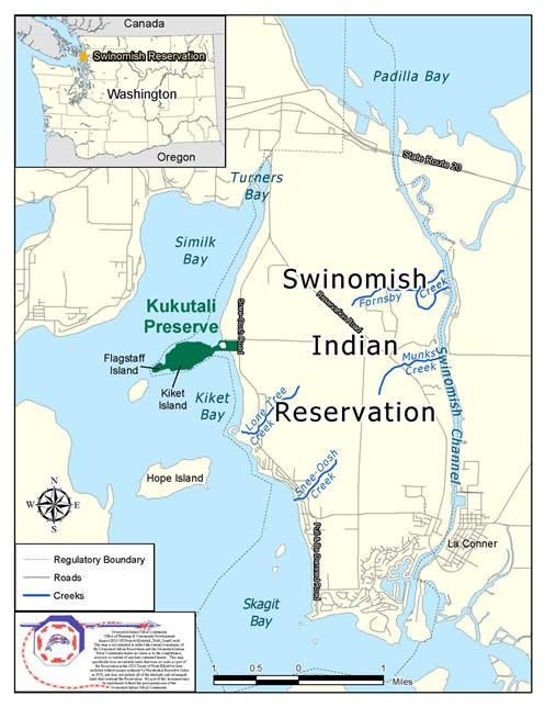
The Swinomish Reservation, as defined by the treaty, was a mere fraction of their ancestral domain. It was established on a peninsula of Fidalgo Island, bordering the Swinomish Channel, a narrow waterway connecting Skagit Bay to Padilla Bay. This new, confined map represented a profound spatial and cultural shift. It was a place of refuge from encroaching settlers, but also a symbol of immense loss and forced relocation for many who had traditionally lived across a much broader area. The lines on this new map were drawn by an external power, reflecting a colonial agenda rather than indigenous understanding of territory. Yet, within these imposed boundaries, the Swinomish people began the arduous work of adapting, preserving, and asserting their identity in a rapidly changing world.
Reading the Reservation Map Today: A Multilayered Document
To look at the official map of the Swinomish Indian Tribal Community today is to view a document layered with history, law, culture, and ongoing struggles for self-determination. It is far more than a simple outline of a geographic area; it is a testament to sovereignty, a blueprint for governance, and a daily reminder of both historical injustice and remarkable resilience.
-
Physical Boundaries and Legal Complexity: The most apparent feature of the map is the physical boundary of the Swinomish Reservation, primarily located on the southeastern part of Fidalgo Island. This encompasses significant shoreline along the Swinomish Channel and Padilla Bay. However, the legal reality is far more complex than a simple contiguous block of land. The map showcases what is often called a "checkerboard" pattern of land ownership. This arose from the General Allotment Act of 1887 (Dawes Act), which aimed to break up tribal communal landholdings into individual parcels, often sold off to non-Natives. As a result, within the reservation boundaries, there are lands held in federal trust for the Tribe, lands held in trust for individual tribal members (allotments), and lands held in "fee simple" by non-Native individuals or entities. This checkerboard creates immense challenges for tribal governance, resource management, and economic development, as the Tribe must navigate varying jurisdictions and interests within its own recognized territory.
-
Cultural and Spiritual Significance: Beyond the legal lines, the map implicitly highlights areas of profound cultural and spiritual importance. While many ancestral sites lie outside the present reservation boundaries, the land within the reservation holds significant meaning. These include ancestral burial grounds, traditional harvesting areas for clams, oysters, and other marine resources, and places associated with oral histories and ceremonies. The Swinomish Channel itself, a vital waterway for travel and trade, remains central to their identity. The map, therefore, is not just about land, but about the spirit of the land, the connections to ancestors, and the ongoing practice of traditional lifeways.
-
Resource Management and Economic Development: The map delineates the Tribe’s primary economic base and resource management areas. The Swinomish Channel and the adjacent bays are crucial for their renowned shellfish aquaculture operations, a testament to their continued connection to marine resources and their commitment to sustainable practices. Forestry, fisheries management, and the operations of the Swinomish Casino & Lodge, located on the reservation, all fall within the jurisdiction outlined by this map. The map thus becomes a tool for economic planning, environmental protection, and the assertion of sovereign rights over natural resources.
-
Sovereignty in Practice: Fundamentally, the Swinomish reservation map represents the territorial basis for the Tribe’s inherent sovereignty. Within these boundaries, the Swinomish Indian Tribal Community exercises governmental authority, operating its own police force, court system, healthcare services, education programs, and environmental protection agencies. It is a nation within a nation, making laws, providing services, and asserting its right to self-governance. The map, therefore, is a visual declaration of their autonomy and their unbroken chain of identity as a distinct political and cultural entity.


Challenges and Resilience: Beyond the Lines
The history encapsulated by the Swinomish map is not without its challenges. The intergenerational trauma of forced assimilation policies, including residential schools that sought to strip children of their language and culture, continues to impact the community. Environmental degradation from industrialization in the surrounding areas has threatened their traditional fishing grounds. Climate change, with rising sea levels and ocean acidification, poses a direct threat to the shellfish beds that are both culturally and economically vital.
Yet, the map also symbolizes profound resilience and resurgence. The Swinomish people have actively worked to revitalize their Lushootseed language, restore cultural practices, and protect their ancestral lands and waters. They are leaders in environmental stewardship, implementing innovative aquaculture techniques and advocating for broader ecological health. Through legal battles, they have consistently affirmed their treaty rights, including fishing rights, and strengthened their governmental authority. The map, in this sense, is not static; it is a dynamic representation of a people actively shaping their future, building economic stability, and preserving their heritage for generations to come.
The Map as a Living Identity: Past, Present, Future
Ultimately, the Swinomish Indian Tribal Community map is more than a geographic delineation; it is a profound statement of identity. It connects the present generation to their ancestors who stewarded the land and waters for millennia. It reminds them of the sacrifices made and the rights fought for. It serves as a constant guide for their responsibilities to the land, their community, and their future generations.
For the Swinomish, the map is an unassailable truth: they are still here, connected to their ancestral lands, even if those lands are now defined by different lines. It represents their continued presence, their cultural vitality, and their unwavering commitment to sovereignty. It is a symbol of their enduring spirit, a testament to their strength in the face of immense change, and a powerful declaration of their right to self-determination.
For the Traveler and Learner: Engaging with Respect
For those traveling through or learning about the Pacific Northwest, understanding the Swinomish map offers a crucial lens through which to view the region. It encourages visitors to look beyond the surface, to recognize the deep historical layers, and to appreciate the enduring presence of Indigenous peoples.
When engaging with the Swinomish Indian Tribal Community, whether visiting their casino, dining at their restaurants, or simply driving through their beautiful lands, remember:
- Respect Sovereignty: Recognize that you are on the lands of a sovereign nation with its own laws and customs.
- Learn and Listen: Seek out opportunities to learn directly from the Swinomish people. Visit their cultural center, if available, or engage with tribal businesses.
- Acknowledge History: Understand the history of treaties, land cessions, and the resilience required to maintain identity and culture.
- Support Tribal Initiatives: Where possible, support tribal enterprises and initiatives that promote cultural preservation and economic development.
The Swinomish Indian Tribal Community map is an invitation – an invitation to delve deeper, to understand the intricate relationship between land, history, and identity, and to respect the enduring legacy of a vibrant Indigenous people. It is a reminder that maps, in their truest form, are not just about where we are, but about who we are, where we’ve been, and where we are going.
