The Living Lines: A Journey Through the Quinault Indian Nation Reservation Map
The Olympic Peninsula of Washington State is a land of breathtaking contrasts – ancient rainforests meet the pounding surf of the Pacific, and glacier-capped peaks give way to vast, salmon-rich rivers. Nestled within this majestic landscape lies the Quinault Indian Nation Reservation, a territory whose boundaries on a map are far more than mere lines. They represent layers of history, a profound cultural identity, and an ongoing testament to the resilience and sovereignty of the Quinault people and their confederated tribes. For any traveler seeking to understand the true essence of this region, or any student of history eager to delve beyond textbooks, exploring the story behind the Quinault map is an indispensable journey.
The Ancestral Tapestry: Before the Lines Were Drawn
Before the arrival of European explorers and settlers, the Quinault people, along with their neighbors and relatives – the Queets, Hoh, Chehalis, Cowlitz, and Chinook – thrived across a vast and rich ancestral territory. This land, stretching from the Olympic Mountains to the Pacific Ocean, was an intricate network of resources and cultural significance. The Quinault River, known as "Kwinai’ult" (meaning "a people of the point of the river"), was the lifeblood of their existence, providing abundant salmon and steelhead. The ocean sustained them with halibut, cod, and whales, while the dense temperate rainforest offered cedar for longhouses, canoes, and clothing, as well as berries, roots, and game.

Life was structured around the seasons, with sophisticated systems of resource management, trade, and social organization. Villages dotted the riverbanks and coastline, connected by a network of trails and waterways. The Quinault people developed a deep spiritual connection to every aspect of their environment, recognizing the interconnectedness of all living things. Their oral histories, ceremonies, and traditional practices were intricately woven into the fabric of the land itself. The map of their ancestral domain was not a static document of ownership, but a living, breathing understanding of stewardship, reciprocity, and identity. Each river bend, forest grove, and coastal bluff held stories, sacred sites, and practical knowledge passed down through generations.
The Imposition of Lines: Treaties, Reservations, and Dispossession
The mid-19th century brought an irreversible shift to the Pacific Northwest. The relentless westward expansion of the United States government, driven by the ideology of Manifest Destiny and the promise of land and resources, collided with the sovereign nations already inhabiting the region. Isaac Stevens, the first governor of Washington Territory, was tasked with negotiating treaties to clear the way for settlement.
The Treaty of Quinault River (also known as the Treaty of Olympia) was signed in 1855. Like many treaties of the era, it was a deeply unequal negotiation. Under duress and with limited understanding of the long-term implications of "ceding" land, the Quinault and Quileute leaders were compelled to relinquish vast ancestral territories to the U.S. government. In return, they "reserved" a small tract of land along the Pacific Coast, an area that became the initial Quinault Reservation. Crucially, the treaty also guaranteed the Quinault people the right to fish, hunt, and gather in their "usual and accustomed places" outside the reservation boundaries – a right that has been fiercely defended and litigated to this day.

However, the story of the reservation’s boundaries did not end there. The initial reservation was deemed too small, especially as timber resources became increasingly valuable. In 1873, President Ulysses S. Grant signed an Executive Order significantly expanding the Quinault Reservation. This expansion was not solely for the Quinault people; it was intended to consolidate various coastal tribes onto a single, larger land base. This decision brought the Queets, Hoh, and some members of the Chehalis, Cowlitz, and Chinook tribes into the Quinault Reservation, creating the "Confederated Tribes of the Quinault Indian Nation" we know today. This act, while expanding the land base, also imposed a new political structure and brought together diverse tribal groups, requiring adaptation and shared governance.
The late 19th and early 20th centuries saw further assaults on Native land ownership, notably through the Dawes Allotment Act of 1887. This federal policy aimed to break up communally held tribal lands into individual allotments, intending to assimilate Native people into mainstream American society and open up "surplus" lands to non-Native settlers. While the Quinault Reservation was initially protected due to its timber value, later legislation did lead to significant allotment, resulting in a complex "checkerboard" pattern of land ownership within the reservation boundaries today – a mix of tribally owned, individually owned, and non-Native owned parcels. This fragmented ownership continues to pose significant challenges for resource management, economic development, and the exercise of tribal sovereignty.
The Map’s Modern Contours: Geography and Demographics
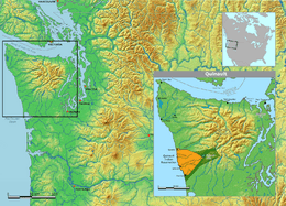
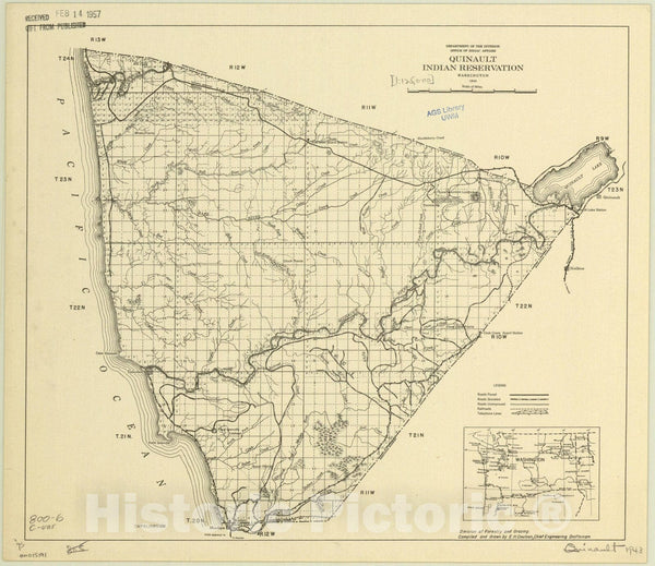
Today, the Quinault Indian Nation Reservation spans approximately 208,150 acres (around 325 square miles) along the Pacific Coast of Washington State, primarily in Grays Harbor County. Its distinctive shape on the map is a testament to its unique history. It includes roughly 23 miles of pristine coastline, stretching from the mouth of the Raft River in the north to the mouth of the Quinault River in the south. Inland, the reservation extends into the foothills of the Olympic Mountains, encompassing temperate rainforest, numerous rivers and streams, and a significant portion of the beautiful Lake Quinault.
The topography is diverse:
- Coastal Strip: Characterized by sandy beaches, dramatic bluffs, and estuaries, vital for shellfish and marine life.
- River Valleys: The Quinault and Queets rivers carve through the reservation, providing essential spawning grounds for salmon and steelhead, and forming fertile valleys.
- Forest Lands: The vast majority of the reservation is covered by old-growth and second-growth temperate rainforest, dominated by Sitka spruce, Western hemlock, Douglas fir, and Western red cedar. These forests are not just timber resources but are culturally significant, providing traditional medicines and materials.
- Lake Quinault: A stunning glacial lake, part of which falls within the reservation boundaries, offering freshwater resources and breathtaking scenery.

The primary population center and tribal capital is Taholah, located at the mouth of the Quinault River. Other smaller communities and settlements are scattered throughout the reservation. The demographics reflect the confederated nature of the Nation, comprising descendants of the Quinault, Queets, Hoh, and other coastal Salish and Chinookan peoples. This rich tapestry of heritage contributes to a vibrant and diverse cultural identity within the Nation.
Identity Woven into the Map: Sovereignty, Culture, and Resilience
For the Quinault people, the map of their reservation is not merely a geographical outline; it is a living embodiment of their identity, sovereignty, and continued existence. Every boundary, every river, every forest stand holds immense cultural, economic, and spiritual significance.
Sovereignty and Self-Governance: The Quinault Indian Nation operates as a sovereign government, exercising jurisdiction over its lands and people. This means having its own tribal council, judicial system, law enforcement, and government departments responsible for everything from health and education to environmental protection and economic development. The reservation map delineates the physical space where this inherent sovereignty is exercised, where tribal laws apply, and where the Nation makes decisions for its own future, independent of state authority.
Resource Management and Economic Development: The land and its resources are the foundation of the Quinault Nation’s economy and self-sufficiency. Sustainable forestry, under the "Quinault Pride" label, is a major economic driver, reflecting a commitment to managing their forests for future generations, not just short-term gain. Fisheries management, particularly for salmon, is another critical aspect, intertwined with cultural practices and economic livelihood. The Nation actively works to protect these vital resources from external threats and to ensure their sustainable harvest, demonstrating a modern application of their ancient stewardship ethics. The map is a framework for this comprehensive resource management strategy.
Cultural Preservation and Revitalization: The reservation provides the physical space for the preservation and revitalization of Quinault culture, language, and traditions. Traditional ceremonies, such as the annual Canoe Journey, connect the people to their ancestral waterways and neighboring tribes. Language immersion programs work to ensure the Quinault language thrives. The land itself is a classroom, where younger generations learn about traditional plant uses, fishing techniques, and the stories embedded in the landscape. The map guides these cultural journeys, pointing to sacred sites, traditional gathering areas, and places of historical memory.
Addressing Modern Challenges: The Quinault Nation faces significant challenges, many of which are directly tied to the land represented on the map. Climate change poses an existential threat, with rising sea levels impacting coastal communities like Taholah, forcing plans for relocation. Ocean acidification threatens shellfish beds, a traditional food source. Increased storm intensity and changes in salmon runs due to warming waters and habitat degradation impact their way of life. The checkerboard land ownership, a legacy of allotment, complicates efforts to manage resources and plan for future development. Despite these challenges, the Quinault people demonstrate remarkable resilience, actively engaging in climate adaptation planning, advocating for environmental protection, and working to strengthen their economic base while honoring their heritage.
Visiting the Quinault Nation: Respectful Engagement
For travelers and history enthusiasts, the Quinault Indian Nation Reservation offers a unique opportunity to experience the beauty of the Olympic Peninsula through a lens of deep respect and understanding. When visiting, it is crucial to remember that you are on sovereign tribal land.
- Respect Tribal Laws and Customs: Adhere to posted signs and regulations.
- Seek Permission: If you wish to visit specific areas that might be culturally sensitive or privately owned by the Nation, inquire respectfully at the tribal offices in Taholah.
- Support Tribal Enterprises: Patronize Quinault-owned businesses, such as the Quinault Lake Lodge (though not tribal-owned, it’s a significant landmark within the reservation and often supports tribal initiatives), or purchase goods from local Quinault artisans.
- Leave No Trace: Practice responsible tourism, pack out everything you pack in, and minimize your environmental impact.
- Learn and Listen: Take the opportunity to learn about Quinault history, culture, and current initiatives. Understanding the stories behind the land enriches the travel experience immeasurably.
The Quinault Indian Nation Reservation map, with its intricate lines and varied terrain, is more than a geographical representation. It is a palimpsest, bearing the indelible marks of ancient lifeways, colonial imposition, and enduring sovereignty. It tells a story of a people deeply connected to their land, who have navigated immense change with strength and determination. To look at this map is to see not just land, but history, identity, and the vibrant, living spirit of the Quinault people. It invites us to look deeper, listen closer, and understand the profound significance of the ground beneath our feet.

