Navigating the Ancient Currents: Exploring the St. Lawrence River Through Indigenous Maps
Forget your GPS for a moment. Close your eyes to the digital overlay and open your mind to a landscape imprinted with millennia of human wisdom. The St. Lawrence River, a majestic artery of North America, is more than just a waterway; it’s a living archive, a narrative carved by glaciers and traversed by countless generations. To truly experience this iconic river, one must journey beyond conventional maps and delve into the profound cartography of its original stewards: the Indigenous peoples whose understanding shaped its very essence.
This isn’t an article about antique paper maps in glass cases. While some early European explorers documented Indigenous sketches or narratives, the true "maps" of the Haudenosaunee, Algonquin, Huron-Wendat, Innu, and other nations were far more dynamic and deeply embedded in their way of life. They were oral traditions, star charts, seasonal calendars, migration routes, spiritual pathways, and a comprehensive ecological knowledge passed down through stories, songs, and physical memory. To review the St. Lawrence through this indigenous lens is to unlock a deeper, richer travel experience, transforming a scenic route into a journey through time and culture.
The St. Lawrence: A Lifeline and a Living Map

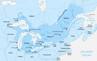
From its source in the Great Lakes to its vast estuary emptying into the Atlantic, the St. Lawrence River has always been a vital corridor. For Indigenous nations, it was Kaniatarowanenneh (Mohawk for "big waterway") or Magtogoek (Algonquin for "the great path that walks"). It was a source of sustenance, a highway for trade and diplomacy, and a sacred landscape. Every bend, every rapids, every island, and every tributary held significance – not just as a geographical feature, but as a place imbued with history, ceremony, and practical knowledge.
Unlike European maps focused on boundaries and conquest, Indigenous cartography was fundamentally relational. It emphasized connections: between land and water, between human and animal, between the visible world and the spiritual realm. These "maps" guided seasonal movements for hunting, fishing, and gathering, identified safe havens and dangerous rapids, marked portage routes that linked different watersheds, and highlighted areas rich in specific resources like wild rice, medicinal plants, or flint for tools. They were survival guides, spiritual texts, and historical records all rolled into one.
Decoding the Indigenous Landscape: What to Look For
To experience the St. Lawrence as Indigenous peoples did, you must engage all your senses and cultivate a deeper observational awareness.

1. The Water Highway: Paddling Through Time
The most authentic way to connect with the ancient routes is by canoe or kayak. Modern recreational paddling mirrors the primary mode of travel for millennia. As you glide across the water, imagine the centuries of paddlers who navigated these same currents.
- Focus on the Currents: Notice the subtle shifts in current, the eddies, and the deeper channels. Indigenous navigators read these signs expertly to conserve energy and avoid dangers.
- Rapids as Landmarks: The Lachine Rapids, near present-day Montreal, were not just obstacles but significant landmarks and spiritual sites. They marked the end of easy upstream travel and necessitated portaging or expert guidance. Today, while most of the rapids are tamed, their memory persists in the river’s character.
- Islands as Waypoints: The Thousand Islands region, a labyrinth of granite and pines, was a crucial area for shelter, fishing, and ceremony. Each island likely had a name and a story, marking resting spots or places of spiritual significance.

2. The Shoreline as a Storybook:
Look beyond the developed banks and imagine the original forests, wetlands, and bluffs.
- Resource Indicators: Were there areas suitable for specific plants? Look for marshy areas that might have yielded wild rice, or rocky outcrops where berries thrived. These were natural "waypoints" on the Indigenous map.
- Portage Trails: While most are overgrown or built over, the concept of portaging remains vital. Consider where natural breaks in the river’s flow would have forced travelers to carry their canoes and goods overland, connecting to other lakes and rivers. These portage routes were the original inter-state highways.
- Sacred Sites: Many cliffs, caves, and specific rock formations held spiritual significance. These places were marked by stories, not necessarily carvings, and represented points of power or ancestral connection. Research local Indigenous histories to understand these deeper layers.

3. Wildlife as Navigators and Guides:
Indigenous maps were inherently ecological. The presence and movement of wildlife were crucial indicators.
- Fish Runs: The seasonal migrations of salmon, sturgeon, and eel determined where and when communities would gather. The abundance of these species shaped settlement patterns along the river.
- Bird Migrations: Waterfowl and migratory birds used the St. Lawrence as a flyway, their movements signaling seasonal changes and providing sustenance.
- Mammals: The presence of beaver, deer, or bear indicated healthy ecosystems and hunting grounds.
Experiencing the Indigenous Legacy Today: A Travel Itinerary
To fully immerse yourself in this ancient cartography, integrate cultural experiences into your journey along the St. Lawrence.
Start in Montreal or Quebec City: These major cities are built on ancient Indigenous crossroads.
- Pointe-à-Callière, Montreal: This museum of archaeology and history sits on the very spot where Montreal was founded, revealing layers of Indigenous habitation stretching back thousands of years. Its exhibits often highlight the river’s importance.
- McCord Museum, Montreal: Features significant collections of Indigenous art and artifacts, providing context to the cultures that thrived along the St. Lawrence.
- Kahnawà:ke Mohawk Territory: Located just south of Montreal, a visit here offers a direct connection to a vibrant Indigenous community whose history is deeply intertwined with the St. Lawrence River, particularly the Lachine Rapids. Look for cultural events or community-led initiatives that welcome visitors.
Journey Eastward Towards Quebec City:
- Wendake (Huron-Wendat Nation): A short drive from Quebec City, Wendake offers an unparalleled opportunity to experience Huron-Wendat culture. The Huron-Wendat Museum, Hotel-Musée Premières Nations, and traditional longhouse offer insights into their history, spirituality, and their deep connection to the St. Lawrence watershed. Consider taking a guided tour to hear stories directly from community members.
- Parc National de la Jacques-Cartier: While not directly on the St. Lawrence, this stunning glacial valley park, a tributary to the river, offers a glimpse into the pristine wilderness that Indigenous peoples navigated. Kayaking or canoeing here allows you to experience a smaller scale of the river’s powerful currents and the surrounding ecosystem.
The Lower St. Lawrence and Gaspésie:
- Bas-Saint-Laurent & Gaspésie: As the river widens into a vast estuary, you enter the traditional territories of the Wolastoqiyik (Maliseet) and Mi’kmaq. Here, the focus shifts to marine life – whales, seals, and abundant fish. Indigenous knowledge of these waters was crucial for survival. Look for opportunities to learn about traditional fishing practices and marine stewardship.
- Innu Communities: Further down the North Shore, towards the Côte-Nord region, you will find Innu communities whose history is intimately tied to the vast forests and the river’s northern tributaries. Their understanding of the boreal forest and its connection to the St. Lawrence is profound.
Respectful Exploration:
When traveling through these landscapes, always practice respectful tourism. Acknowledge the traditional territories you are visiting, support Indigenous-owned businesses, and seek out opportunities to learn directly from Indigenous peoples. Their oral traditions are the true "maps" that continue to guide our understanding of this magnificent river.
The Deeper Journey: Re-Orienting Your Perspective
Traveling the St. Lawrence River with an Indigenous "map" in mind is not about finding specific coordinates; it’s about re-orienting your entire perspective. It’s about seeing the river not as a static line on a chart, but as a dynamic, living entity. It’s about understanding that every feature, every current, every forest, and every animal is part of an intricate web of relationships.
This approach transforms a simple scenic drive or boat trip into a profound cultural and historical immersion. You begin to appreciate the resilience, ingenuity, and deep spiritual connection that Indigenous peoples have maintained with this land for thousands of years. It’s an invitation to listen to the whispers of the wind and the currents, to observe the landscape with new eyes, and to understand that the St. Lawrence River, in its essence, is an enduring testament to the wisdom of its original navigators. Embark on this journey, and you’ll find that the river reveals secrets far deeper than any modern map could ever convey.
