Navigating Ancient Waters: Unveiling the Missouri River Through Native American Maps
Forget the static, colonial lines etched onto parchment. To truly understand the Missouri River system, that magnificent artery pulsing through the heart of North America, one must look beyond the familiar cartographic narratives. We’re talking about maps that breathed, that told stories, that were drawn on hides, etched into memory, and passed down through generations. These are the Native American maps, a cartographic heritage often overlooked, yet profoundly vital to comprehending the river’s historical, cultural, and even spiritual significance.
Our journey takes us to the Upper Missouri River Corridor, specifically the lands now encompassing North Dakota, a region that served as a bustling crossroads for centuries. Here, the Mandan, Hidatsa, and Arikara peoples, among others, built thriving agricultural and trading societies. Their intimate knowledge of this vast and intricate river system was not just practical; it was a cornerstone of their existence, reflected in maps that far predated European encounters and often surpassed them in detail and accuracy.
More Than Lines: The Living Cartography of Indigenous Peoples

When we speak of Native American maps, we aren’t limited to the paper-based artifacts we typically associate with cartography. Indigenous mapping traditions were fluid, dynamic, and deeply integrated into their oral cultures and daily lives. Maps could be drawn on tanned hides (like buffalo or deer skin), etched into bark, carved into wood, or even sketched into the earth with sticks. They were often ephemeral, drawn for a specific purpose – to guide a hunting party, illustrate a trade route, or explain a battle strategy – and then erased, their knowledge absorbed into communal memory.
These maps were not just about geographical features; they were repositories of ecological knowledge, spiritual beliefs, and historical events. They marked not only rivers, bluffs, and prairies but also significant resource locations, sacred sites, buffalo jumps, and the territories of neighboring tribes. Crucially, they emphasized relational space – how one place connected to another, the time it took to travel between them, and the resources available along the way. This dynamic, experiential approach to mapping stands in stark contrast to the static, top-down perspective often favored by European cartographers.
The accuracy of these indigenous maps was astounding. European explorers, initially armed with crude instruments and limited understanding of the vast North American interior, frequently found themselves lost or misinformed. It was only by relying on the superior geographical knowledge of Native American guides and their maps that expeditions like that of Lewis and Clark were able to navigate the complex web of the Missouri and its tributaries. Imagine a Mandan elder, with a stick in the dirt, outlining a thousand-mile stretch of river, complete with accurate confluences, portages, and descriptions of the people living along its banks. This was not uncommon; it was the norm.
The Missouri: A Network of Life, Mapped by Its Keepers

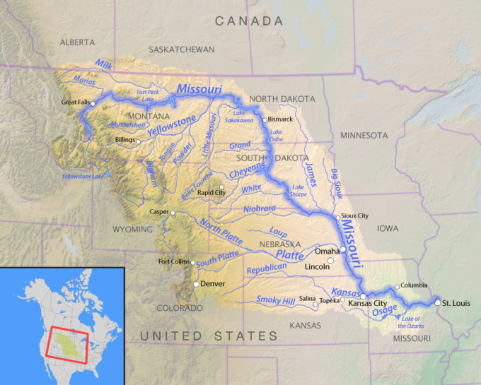
The Missouri River, known as "Miní Shošhe" (meaning "muddy waters" or "water that is full of things") to the Lakota, was more than just a waterway; it was the central nervous system of a vast and interconnected world. For the Mandan, Hidatsa, and Arikara, their earthlodge villages were strategically placed along its banks, serving as hubs for agriculture, trade, and defense. Their maps meticulously depicted the river’s meandering course, its islands, and the countless smaller streams that fed into it, each with its own significance for water, game, or plants.
These maps also detailed the portages – the overland routes used to bypass rapids or connect different river systems – demonstrating an understanding of the broader hydrological network that allowed for efficient travel and trade across immense distances. They showed where the buffalo herds congregated, where medicinal plants could be found, and where spiritual ceremonies were performed. The river itself, with its ever-changing currents and seasonal floods, was a living entity, and indigenous maps captured this dynamism, reflecting an ecological intimacy that modern maps often lack.
Consider the concept of "river miles" as depicted in these maps. It wasn’t just a linear distance but often incorporated travel time, difficulty of navigation, and even the emotional or spiritual significance of the journey. A bend in the river might be marked not just as a geographical feature but as the site of an important encounter, a place of good hunting, or a warning of danger. This holistic approach imbued the landscape with layers of meaning, making the maps rich tapestries of knowledge and experience.
Lewis and Clark: Guided by Indigenous Genius

The most famous intersection of European exploration and Native American cartography occurred during the Lewis and Clark Expedition (1804-1806). As they pushed up the Missouri, the explorers quickly realized the limitations of their own maps and the indispensable value of indigenous knowledge. Their journals are replete with instances where Native American guides, notably Sacagawea and her fellow Shoshone, Mandan, and Hidatsa interlocutors, provided critical geographical information.
One of the most famous examples is the Mandan map drawn on a hide, depicting the Missouri River upstream from their villages, complete with tributaries, mountain ranges, and the locations of various tribes. This map, transcribed by Clark, proved invaluable in guiding the expedition through the unknown territories of present-day Montana and beyond. It showed them the Three Forks of the Missouri, where the river truly began, and crucially, the portage around the Great Falls, a monumental obstacle that would have stalled their progress without this pre-existing knowledge.
Sacagawea’s role, too, cannot be overstated. Her personal knowledge of the Shoshone homelands and her ability to identify landmarks, interpret the landscape, and communicate with other tribes were geographical assets of immeasurable value. She wasn’t just a guide; she was a living map, embodying generations of indigenous geographical understanding. Lewis and Clark’s success was, in large part, a testament to their willingness (and necessity) to integrate and respect this sophisticated indigenous cartography.
Experiencing the Landscape Through Ancient Lenses: A Traveler’s Guide to the Upper Missouri
Today, to truly appreciate the Missouri River through the lens of Native American maps, one must visit the very landscapes that were so intimately known and meticulously depicted. Our recommended "location" is not a single point on a map but rather the Upper Missouri River Corridor in North Dakota, with a specific focus on sites like the Knife River Indian Villages National Historic Site near Stanton, North Dakota.
Knife River Indian Villages National Historic Site offers a profound opportunity to step back in time. This site preserves the archaeological remains of several Mandan and Hidatsa villages, continuously occupied for hundreds of years. Here, you can walk among the depressions of ancient earthlodges, imagine the bustling trade that occurred, and stand on the banks of the Knife River, where it flows into the mighty Missouri – a confluence that was a key geographical marker on countless indigenous maps.

- What to See and Do:
- Reconstructed Earthlodge: Step inside a full-scale replica of a Mandan/Hidatsa earthlodge to understand the living conditions, communal spirit, and architectural ingenuity of these peoples. Imagine conversations here, where elders might have outlined maps in the dirt floor for hunters or traders.
- Village Remains: Wander the trails that wind through the ancient village sites. The interpretive signs provide context, explaining the significance of each area – from council circles to storage pits. As you walk, consider that every path, every turn in the river, every distant bluff was once a mapped feature, imbued with meaning and purpose.
- Missouri River Views: The site offers breathtaking views of the Missouri River. Stand at the confluence of the Knife and Missouri rivers, and try to visualize the river as a living map. Think about the canoes traversing these waters, laden with goods, guided by knowledge passed down through generations.
- Visitor Center Exhibits: The museum within the visitor center houses artifacts and exhibits that delve into the history, culture, and mapping traditions of the Mandan, Hidatsa, and Arikara. Look for displays that highlight indigenous knowledge systems and their contributions to early American exploration.
Beyond Knife River: The entire Upper Missouri River corridor offers further opportunities for immersive understanding. Consider:
- Fort Abraham Lincoln State Park (near Mandan, ND): Home to the reconstructed On-A-Slant Mandan Village, providing another tangible connection to the riverine communities.
- The Lewis and Clark Riverboat (Bismarck, ND): While a modern vessel, a cruise on the Missouri can help you appreciate the scale and power of the river, allowing you to imagine the challenges and triumphs of ancient and early European travelers alike.
- The Missouri-Yellowstone Confluence Interpretive Center (near Williston, ND): This is another critical confluence point, heavily mapped and utilized by Native Americans, offering insights into the broader trade networks.
Connecting the Past to the Present:
Visiting these sites with an awareness of Native American cartography transforms the experience. It’s not just about seeing a river; it’s about seeing the river as a living document, a geographical narrative penned by indigenous hands and minds. It challenges us to decolonize our understanding of maps and history, to recognize the profound intellect and environmental wisdom of the continent’s first peoples.
These indigenous maps are not merely historical curiosities; they are vibrant testaments to a deep, reciprocal relationship between people and land. They offer an alternative way of seeing, one that emphasizes connection, stewardship, and the rich layers of meaning embedded in every landscape feature. They remind us that the Missouri River, far from being an untamed wilderness, was a thoroughly known and meticulously understood system, navigated and sustained by its original inhabitants for millennia.
Traveler’s Insights:
- Best Time to Visit: Spring and fall offer pleasant weather for exploring, with fewer crowds. Summers can be hot, but river activities are popular. Winters are harsh but offer a stark, beautiful landscape.
- What to Bring: Comfortable walking shoes, water, sun protection, and a keen sense of curiosity. A good pair of binoculars will enhance wildlife viewing along the river.
- Respectful Engagement: Always approach indigenous history and culture with respect. Seek out and support local tribal museums, cultural centers, and indigenous-led tours where available. This is how the legacy truly continues.
Conclusion: A New Map for the Soul
Exploring the Upper Missouri River through the lens of Native American maps is more than just a historical excursion; it’s a journey into a different way of knowing and being in the world. It’s an invitation to understand the land not as an empty space to be conquered, but as a vibrant, interconnected system, intimately known and lovingly mapped by those who called it home for countless generations. So, next time you gaze upon the mighty Missouri, remember the unseen cartographers – the elders, hunters, traders, and storytellers whose maps, though often invisible to the modern eye, continue to flow through the very heart of this ancient, majestic river. Let their wisdom be your guide.
