
Mesa Verde: Walking the Ancient Paths – Where Indigenous Maps Still Guide the Way
Forget the GPS, ditch the folded paper maps. At Mesa Verde National Park, the landscape itself is the map, etched by millennia of human ingenuity and spiritual understanding. This isn’t just a collection of remarkable ruins; it’s a living testament to the Ancestral Puebloans’ profound connection to their world, a connection so deep it formed an invisible cartography guiding every aspect of their lives. My recent journey into this UNESCO World Heritage site wasn’t merely a visit; it was an immersion into a world where every cliff dwelling, every kiva, every alignment of stone speaks volumes about how people once understood and navigated their complex environment. It’s a place that compels you to consider what a "map" truly means, extending beyond lines on paper to encompass a holistic, deeply ingrained knowledge of land, sky, and community.
Stepping into Mesa Verde is like stepping into a vast, open-air museum, yet the exhibits are not behind glass but carved into the very earth. The winding roads, clinging precariously to mesa tops, immediately begin to tell the story. As you ascend, the panoramic views of canyons and plateaus unfold, hinting at the challenges and opportunities this rugged terrain presented. This initial ascent itself is a form of orientation, a physical act of entering a different dimension, a world meticulously shaped and understood by its original inhabitants.
The "maps" of the Ancestral Puebloans were not the cartographic grids we recognize today, but rather a sophisticated, multi-layered comprehension of their environment. This indigenous mapping encompassed practical survival, spiritual connection, and social organization, all interwoven into the fabric of their daily existence.
 "Mesa Verde: Walking the Ancient Paths – Where Indigenous Maps Still Guide the Way")
Architectural Cartography: Dwellings as Navigational Points
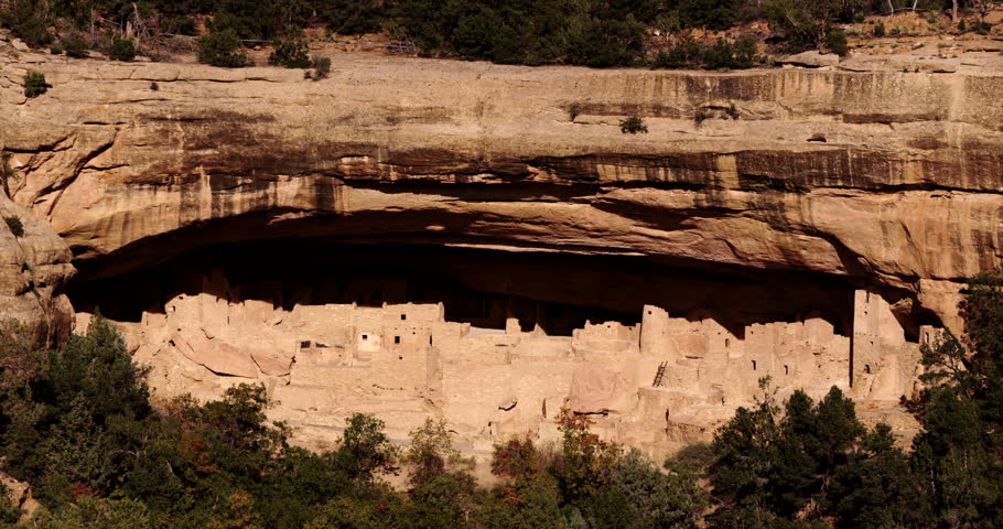
Nowhere is this indigenous mapping more evident than in the iconic cliff dwellings. Consider Cliff Palace, the largest and perhaps most breathtaking of them all. Its strategic placement within a massive, south-facing alcove wasn’t accidental. This was a deliberate architectural "map" – a response to environmental conditions. The south-facing orientation allowed for passive solar heating in the cold winter months, while the overhanging cliff provided crucial shade during the scorching summer. The location also offered natural defense and proximity to water sources. Every wall, every room, every plaza within Cliff Palace was a calculated decision, mapping out a community’s needs for shelter, security, and social interaction. To walk its narrow pathways and climb its ancient ladders is to trace the very lines of their existence, a physical journey through their ingenious design.
Balcony House, another marvel, exemplifies a different facet of their mapping. Its more arduous access—requiring climbs up long ladders and crawls through a tunnel—speaks to its defensive considerations. The Ancestral Puebloans "mapped" out potential threats and vulnerabilities, building their homes in ways that maximized security. The ingenious water catchment system at Balcony House further illustrates their detailed understanding of local hydrology – a critical resource mapped and managed with precision. These aren’t just buildings; they are three-dimensional maps of resilience and foresight.
Spruce Tree House, accessible year-round and nestled in a large, naturally protected alcove, further demonstrates their adaptive "mapping." Its sheer size and the presence of numerous kivas suggest a central role in communal life. The way the structures conform to the natural contours of the cave, utilizing every available space, showcases a profound respect for and integration with their environment. Their homes weren’t imposed upon the land but grew organically from it, a perfect symbiosis that formed a natural, living map of their presence.

Astronomical Maps: The Sky as a Calendar and Compass
Beyond the physical placement of dwellings, the Ancestral Puebloans also "mapped" the heavens. While direct astronomical alignments in Mesa Verde’s cliff dwellings are less overtly dramatic than, say, the Sun Dagger at Fajada Butte (in nearby Chaco Culture National Historical Park), the general orientation of many kivas and ceremonial spaces suggests an awareness of solstices and equinoxes. The movement of the sun across the canyon walls would have served as a critical calendar, mapping the changing seasons, crucial for agricultural cycles, hunting patterns, and ceremonial timing. Their celestial observations were not abstract science but a vital, practical map for survival and spiritual alignment. The very rhythm of their lives was charted by the sun, moon, and stars, integrating the cosmos into their earthly existence.
Resource Mapping: Sustenance from the Land
The Ancestral Puebloans were master resource managers, and their settlement patterns reflect a meticulous "mapping" of the land’s bounty. While the famous cliff dwellings grab attention, the earlier pithouses and surface pueblos on the mesa tops are equally important. Sites like those along the Mesa Top Loop Road, such as Square Tower House and Sun Temple, demonstrate how communities evolved and spread, always in relation to arable land, water sources, and access to timber and game. The presence of reservoirs and check dams further highlights their sophisticated hydrological "maps," understanding where water could be collected and stored for crops. Their agricultural fields, often terraced, were a testament to their knowledge of soil, microclimates, and water runoff – an agricultural map etched into the very landscape.

Spiritual and Social Maps: The Kiva as a Cosmic Center
The layout of their villages and the centrality of kivas represent another layer of indigenous mapping – a spiritual and social cartography. Kivas, circular subterranean or semi-subterranean structures, were not merely rooms but sacred spaces, microcosms of their cosmos. Their design, often with a sipapu (a small hole representing the place of emergence from the underworld), symbolically mapped their spiritual journey and connection to the earth and sky. The organization of kivas within a community reflected their social order, their clan structures, and the communal ceremonies that bound them together. These were maps of their worldview, guiding their collective identity and spiritual practices.
The Petroglyph Point Trail: Pictorial Maps and Narratives
For a more direct, albeit enigmatic, connection to their forms of visual communication, the Petroglyph Point Trail is a must-do. Here, ancient rock art adorns the canyon walls. While not "maps" in the conventional sense, these petroglyphs and pictographs are visual narratives, symbols, and perhaps even calendrical markers. They are snippets of an ancient language, visual "maps" of stories, beliefs, and perhaps even migration routes or significant events. To stand before these ancient etchings is to ponder the messages they intended to convey, an intimate glimpse into their symbolic landscape.
The Journey Through Mesa Verde: A Traveler’s Perspective
Visiting Mesa Verde is a deeply immersive experience. The drive itself is part of the adventure, offering breathtaking vistas from overlooks like Mesa Verde Point and Park Point. The sheer scale of the canyons and the seemingly endless mesa tops instill a sense of awe and humility. The air, often crisp and carrying the scent of juniper and pinyon, adds to the sensory richness.

The ranger-led tours are invaluable. Our guide, knowledgeable and passionate, brought the silent stones to life, explaining the intricacies of their construction, the rhythms of their daily lives, and the mysteries of their departure. Climbing the ladders into Balcony House, or navigating the intricate passages of Cliff Palace, you can almost hear the echoes of ancient voices, feel the presence of those who meticulously planned and lived within these spaces. It’s a physical and emotional journey that bridges millennia.
The Chapin Mesa Archeological Museum provides an excellent interpretive overview, showcasing artifacts and detailed models that help visualize the communities and their way of life. It’s here that modern archaeological "mapping" helps us understand the ancient indigenous "maps" – piecing together the puzzle of their settlements, their resources, and their spiritual world.
Practical Tips for Your Own Expedition:
- Timing is Key: Spring and Fall offer the most pleasant weather and fewer crowds. Summer is busy and hot, requiring early starts. Winter provides a quiet, serene experience, though fewer tours are available.
- Book Tours in Advance: Ranger-led tours for Cliff Palace, Balcony House, and Long House (on Wetherill Mesa) are essential for entry and fill up quickly, especially during peak season. Reserve online weeks, if not months, ahead.
- What to Bring: Water (plenty!), sturdy hiking shoes (expect uneven terrain, ladders), sun protection (hat, sunscreen), layers of clothing, and snacks.
- Accessibility: While some overlooks and the museum are accessible, many cliff dwellings require climbing ladders and navigating tight spaces. Check specific tour requirements.
- Time Commitment: To truly appreciate Mesa Verde, allocate at least two full days. One day for Chapin Mesa (Cliff Palace, Spruce Tree House, Mesa Top Loop) and another for Wetherill Mesa (Long House, Step House, Long House Loop trail – a more remote, reflective experience).
- Lodging: Far View Lodge (seasonal) offers convenient on-site accommodation. Morefield Campground provides camping options. Cortez, a short drive away, has more hotel choices.
- Respect the Site: These are fragile cultural treasures. Stay on marked paths, do not touch the structures, and pack out everything you pack in.
Mesa Verde is more than a historical site; it’s a masterclass in human adaptation and ingenuity, a place where the land speaks volumes about the people who called it home. The "maps" of the Ancestral Puebloans aren’t dusty parchments; they are the very canyons, the meticulously placed stones, the celestial alignments, and the enduring spirit of a civilization that understood its world with unparalleled depth. To walk its paths is to connect with an ancient wisdom, to see the world through eyes that mapped not with lines on paper, but with the very fabric of existence. It’s a journey that redefines what a map can be, urging us to look beyond the obvious and find the profound narratives etched into the landscape itself. This isn’t just a review of a destination; it’s an invitation to embark on a journey of discovery, to walk in the footsteps of those who truly knew their place in the world, and perhaps, to find a deeper understanding of your own.
