Decoding the Land: A Journey Through Indigenous Maps at the National Museum of the American Indian
Forget the neatly gridded, politically bordered maps you’re used to. To truly understand the land beneath our feet, to grasp its stories, its spiritual resonance, and its ancient pathways, one must learn to read the maps of its original caretakers. These are not always paper or parchment, but rather the landscape itself, the stars, oral traditions, petroglyphs, and intricate cultural artifacts. For a traveler seeking a profound encounter with this indigenous cartography, the National Museum of the American Indian (NMAI) in Washington D.C. stands as an unparalleled gateway, a living text where the land’s true narratives are unveiled.
Stepping into the NMAI, one immediately senses a departure from conventional museum experiences. The building itself, a curvilinear structure of Kasota limestone, evokes ancient rock formations shaped by wind and water, aligning with cardinal directions and the rising sun. This isn’t just architecture; it’s an initial lesson in Indigenous spatial understanding, where the built environment reflects a deep reverence for natural forces and cosmological order. For any traveler passionate about history, culture, and the art of seeing the world through different eyes, the NMAI offers an immersive journey into the very heart of how Native American peoples have historically mapped, understood, and related to their lands.
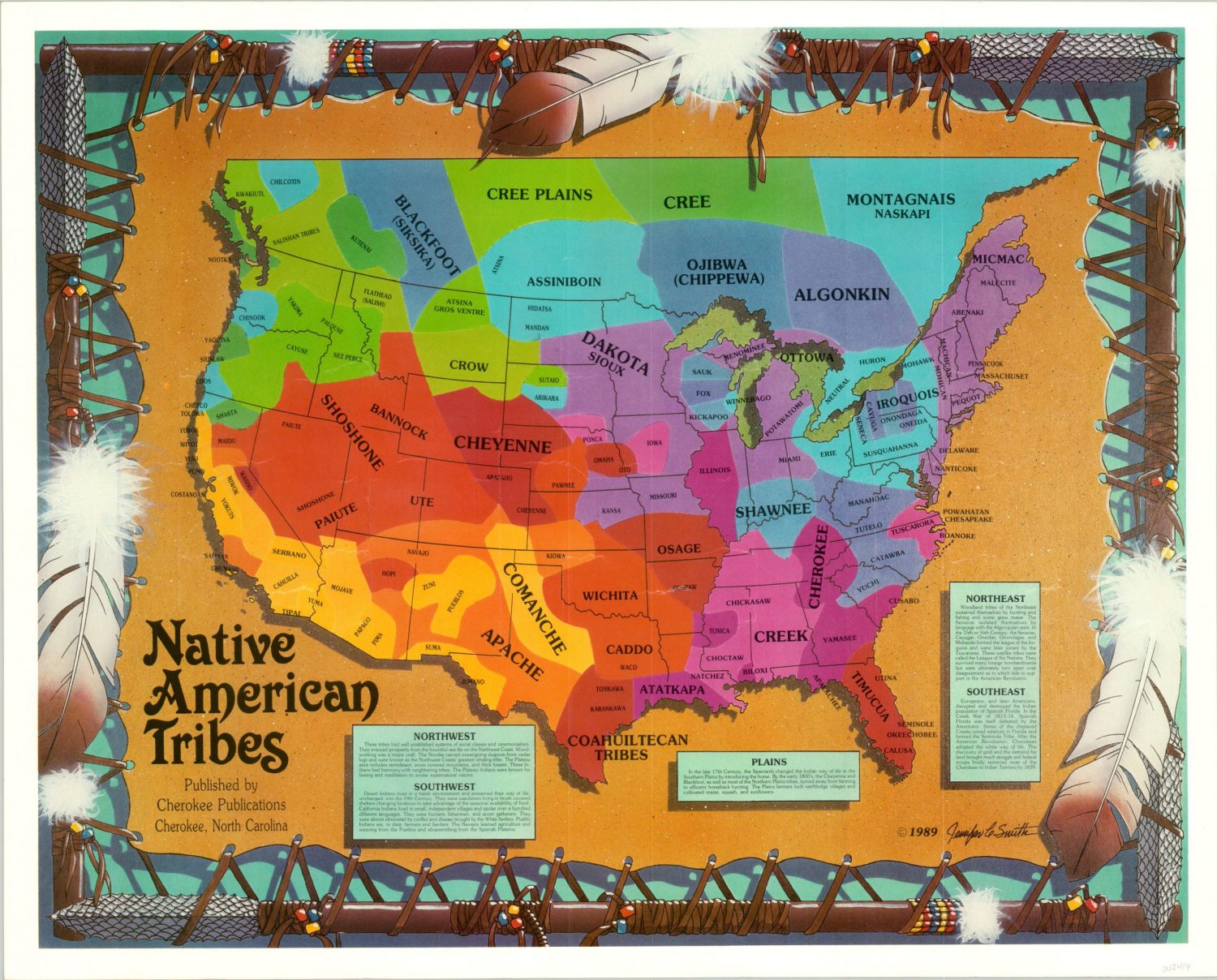
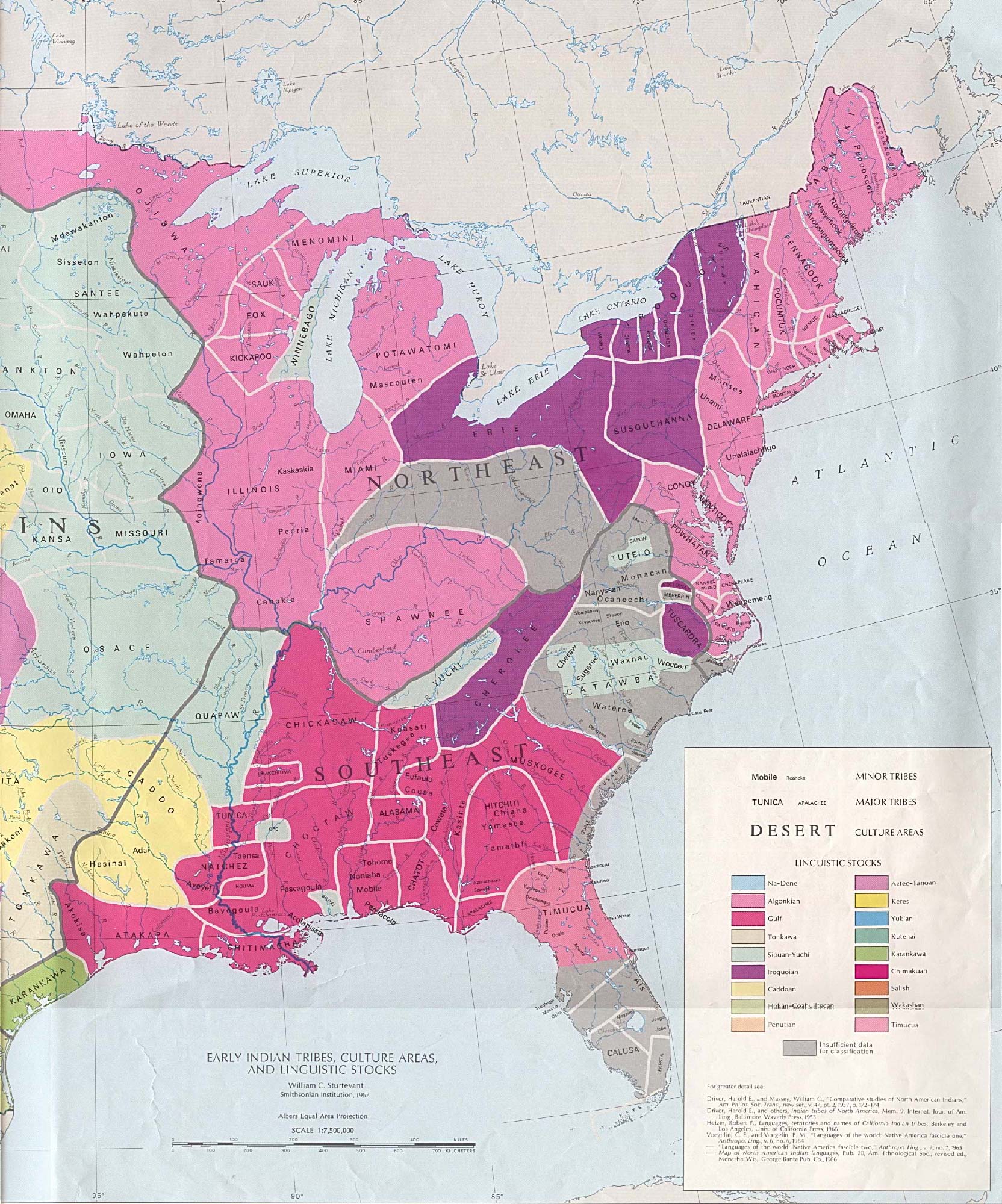
The core of interpreting historical Native American maps lies in broadening our definition of what a "map" actually is. Western cartography typically focuses on precise measurements, political boundaries, and navigational utility. Indigenous maps, however, often prioritize spiritual connection, resource management, ceremonial routes, ancestral migration paths, and the intricate web of relationships between people, animals, and the environment. They are dynamic, imbued with meaning, and frequently transmitted through oral histories, ceremonial practices, and mnemonic devices that encode vast amounts of spatial and ecological knowledge. The NMAI excels in presenting this multifaceted approach, encouraging visitors to move beyond two-dimensional representations and engage with spatial understanding as a holistic, living concept.

Architecture as a Primer: Reading the NMAI Itself
Before even reaching the exhibits, the NMAI’s design begins the interpretive process. The building faces east, greeting the sunrise, a common orientation in many Indigenous cultures. Its materials, sourced from the earth, and its flowing, organic forms resist the rigid geometry of surrounding federal buildings. This thoughtful design is a direct manifestation of Indigenous spatial philosophy – a reminder that land is not just territory, but a living entity with spirit and memory. The building’s relationship to its surroundings, the Potomac River, and the sky above subtly teaches visitors to look for connections and patterns in the environment, much as historical Indigenous maps do. The very act of navigating the museum, with its circular atrium and flowing pathways, mirrors the non-linear, interconnected nature of Indigenous knowledge systems.
Unveiling the "Maps" Within: Galleries of Indigenous Spatial Wisdom
The NMAI’s permanent exhibitions, particularly "Our Universes: Native Peoples’ Perspectives on the World" and "Our Peoples: Native Peoples’ Futures, Native Choices," are where the concept of Indigenous mapping truly comes alive. These galleries are not organized chronologically or by geographical region in the typical Western sense, but rather thematically, reflecting the diverse worldviews of Native nations.

In "Our Universes," visitors encounter the cosmological maps that guided countless generations. Here, the stars are not just distant points of light but celestial markers, storytellers, and guides. Displays on the Lakota star knowledge, for instance, reveal how constellations were used for navigation, agricultural timing, and understanding spiritual journeys. These are not "maps" in the conventional sense, but intricate systems of spatial and temporal orientation, deeply embedded in cultural narratives. The museum effectively uses multimedia, traditional artwork, and compelling oral histories to convey how these celestial maps provided a comprehensive understanding of the universe and humanity’s place within it. One might see a beautiful star blanket from the Plains, its patterns reflecting astronomical knowledge, acting as a textile map of the heavens.
"Our Peoples" delves into the human relationship with the land, focusing on histories of migration, adaptation, and resilience. This is where the landscape itself becomes a map of memory and identity. Exhibits might feature detailed models of ancestral villages, demonstrating sophisticated understanding of resource management, defense, and community planning – spatial knowledge manifested in physical form. Artifacts like intricately carved canoes from the Pacific Northwest tell stories of vast maritime trade routes and deep knowledge of coastal currents and navigation. Wampum belts from the Iroquois Confederacy, often depicting agreements and territorial boundaries, serve as mnemonic maps, their bead patterns encoding historical treaties and the relationships between nations. The museum’s interpretive panels and accompanying audio guides are crucial here, providing the context necessary to "read" these objects not just as art, but as repositories of complex spatial data.
The museum also powerfully addresses the impact of colonial cartography. Visitors witness the stark contrast between Indigenous understandings of fluid, shared territories and the rigid, often arbitrary lines drawn by European colonizers. This juxtaposition highlights the political power of mapping and how Western maps were used as tools of dispossession. By presenting Indigenous perspectives first, the NMAI empowers visitors to critically examine the biases inherent in historical maps and to appreciate the enduring significance of Native place-names and territorial claims.
Beyond Physical Artifacts: Oral Traditions and Performance as Maps

A critical aspect of historical Native American mapping is its reliance on oral tradition. Unlike static paper maps, oral maps are dynamic, adaptable, and carry layers of cultural meaning. The NMAI skillfully integrates storytelling, performance, and video testimonials from contemporary Native elders and knowledge keepers. These narratives often describe ancient migration routes, resource locations, sacred sites, and the names of places in Indigenous languages – each name a miniature map in itself, encoding a story, a history, or an ecological detail.
Imagine listening to a Navajo elder describe a journey through Canyon de Chelly, not just listing landmarks, but weaving in ancestral stories, warnings about certain areas, and spiritual connections to specific rock formations. This is a map that is felt and experienced, not just seen. The NMAI, through its commitment to giving voice to Native peoples, allows visitors to engage with these powerful, living maps, fostering a deeper, more empathetic understanding of Indigenous relationships to land.
The Mitsitam Cafe: A Culinary Map
Even the museum’s renowned Mitsitam Cafe ("Let’s Eat!" in the Piscataway and Delaware languages) serves as an unexpected, yet delicious, form of cartography. It offers dishes from five geographical regions of the Americas: Northern Woodlands, South America, Northwest Coast, Mesoamerica, and Great Plains. Each plate tells a story of the land, its bounty, and the culinary traditions shaped by diverse environments. Eating here becomes an act of geographical exploration, a sensory map that connects you to the continent’s indigenous foodways and the vast knowledge of plants, animals, and agricultural practices that sustained these cultures for millennia.
Why the NMAI is an Essential Stop for the Conscious Traveler
For the traveler eager to delve beyond superficial history, the NMAI offers an unparalleled opportunity to interpret historical Native American maps in their broadest, most profound sense. It’s a place that challenges conventional notions of geography and history, replacing them with a vibrant, interconnected understanding of land, culture, and identity.

- A Shift in Perspective: The NMAI doesn’t just display artifacts; it reframes how we view the world, encouraging a deeper appreciation for Indigenous knowledge systems. You’ll leave understanding that maps are not just tools for navigation but profound cultural expressions.
- Authentic Voices: Unlike many museums that interpret Indigenous cultures for visitors, the NMAI is unique in its commitment to presenting Native voices and perspectives directly, providing a truly authentic interpretive experience.
- Immersive Learning: Through its architecture, diverse exhibits, and emphasis on oral traditions, the museum creates an immersive environment that makes learning about complex spatial knowledge engaging and accessible.
- Timeless Relevance: Understanding how Indigenous peoples have historically mapped and managed their lands offers crucial insights into contemporary issues of environmental stewardship, land rights, and cultural preservation.
Practical Tips for Your Visit:
- Allow Ample Time: This is not a museum to rush through. Dedicate at least 3-4 hours, or even a full day, to truly absorb the depth of the exhibits.
- Engage with the Audio Guides and Narratives: Many exhibits feature audio components with Native voices, which are invaluable for understanding the nuances of the "maps" presented.
- Visit the Mitsitam Cafe: It’s more than just a meal; it’s an extension of the cultural experience.
- Check for Special Events: The NMAI frequently hosts cultural performances, lectures, and workshops that further enhance the interpretive journey.
- Reflect and Connect: Take time to sit in the central atrium and reflect on the interconnectedness of all things, a central theme of Indigenous worldviews.
In a world increasingly defined by digital maps and satellite imagery, the National Museum of the American Indian offers a vital counter-narrative. It invites us to slow down, listen, and learn to read the maps that have always been there – etched into the land, whispered in stories, and woven into the very fabric of Indigenous existence. It’s a journey not just across space, but through time and consciousness, revealing the profound wisdom embedded in Native American ways of seeing the world. For any traveler seeking to truly understand North America, interpreting these indigenous maps at the NMAI is an indispensable first step.
