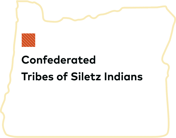
The map of the Confederated Tribes of Siletz Indians in Oregon is far more than a cartographic representation; it is a profound narrative etched onto the landscape, a testament to resilience, sovereignty, and an unbroken connection to ancestral homelands. For the traveler and history enthusiast, understanding this map is to embark on a journey through centuries of vibrant culture, devastating displacement, and an extraordinary resurgence against overwhelming odds. It is an invitation to look beyond geographical lines and appreciate the living history and enduring identity of a people.
I. The Ancestral Tapestry: Before the Lines Were Drawn
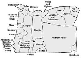
Before the arrival of Euro-American settlers, the vast expanse of what is now Western Oregon was a mosaic of diverse Indigenous cultures. The Siletz map, in its broadest interpretation, delineates the ancestral territories of numerous distinct tribes and bands, many of whom would later be forcibly confederated. These included the Alsea, Coos, Lower Umpqua, Siuslaw, Tututni, Chetco, Tillamook, Shasta, Takelma, and others – each with their own languages, spiritual practices, and intricate social structures. Their territories stretched from the Pacific coast, rich with salmon, shellfish, and marine mammals, eastward into the fertile valleys and dense forests, providing abundant game, camas, and acorns.
Life was deeply interwoven with the rhythms of the land and sea. Sophisticated knowledge of ecology allowed for sustainable harvesting practices, ensuring resources for future generations. Trade networks connected these diverse groups, fostering cultural exchange and alliances. The absence of modern political borders on this ancient landscape speaks to a fluidity of movement and a shared understanding of stewardship. This foundational layer of the Siletz map represents an era of self-sufficiency, cultural richness, and deep spiritual connection to every river, mountain, and bay – a memory that persists in the collective identity of the Confederated Tribes.

II. The Cartography of Displacement: Treaties and the Coast Reservation
The mid-19th century brought seismic shifts to this ancient landscape. The Oregon Trail, the California Gold Rush, and relentless westward expansion dramatically increased settler pressure on Indigenous lands. The United States government, driven by a policy of "Manifest Destiny" and "Indian Removal," sought to consolidate Native populations onto reservations to open up vast territories for non-Native settlement and resource extraction.
Between 1853 and 1855, a series of coerced treaties were signed, often under duress and misunderstanding, leading to the cession of millions of acres of tribal lands. The Siletz map vividly illustrates this period, marking the initial, vast ancestral territories alongside the dramatically shrunken reservation boundaries. The primary destination for many of these displaced tribes was the Coast Reservation, established by executive order in 1855. This narrow, approximately 100-mile-long strip of land along the rugged Oregon coast, from Cape Lookout south to the Siuslaw River, became the designated home for over two dozen different tribes and bands.
The journey to the reservation was a harrowing "Trail of Tears" for Oregon’s Indigenous peoples. Forced marches, often in brutal conditions, saw thousands removed from their traditional homes, enduring starvation, disease, and violence. The Siletz Agency, located near the modern town of Siletz, became the administrative center for these diverse groups, many of whom had been historical rivals or spoke mutually unintelligible languages. This forced convergence was a deliberate strategy to break down traditional tribal structures and facilitate assimilation. The map of this era is a stark reminder of massive land theft and the violent uprooting of entire communities.

III. Forging a New Identity: Life on the Siletz Reservation
Life on the newly formed Coast Reservation, and specifically at the Siletz Agency, was a crucible of immense hardship and remarkable adaptation. The diverse tribes, stripped of their traditional lifeways, faced poverty, disease, and cultural suppression. Federal agents often banned traditional ceremonies, languages, and governing structures. Despite these immense challenges, a new, shared identity began to emerge. Intermarriage became common, as did the adoption of shared customs and a common language (often Chinook Jargon, a trade language). The experience of shared displacement, resilience, and the fight for survival began to forge the diverse groups into a new, unified entity: the Confederated Tribes of Siletz Indians.
However, even the reduced reservation lands were not secure. The General Allotment Act (Dawes Act) of 1887, ostensibly designed to "civilize" Native Americans by turning them into individual farmers, further fragmented the Siletz land base. Communal tribal lands were divided into individual allotments, and any "surplus" land was declared available for sale to non-Native settlers. This policy resulted in the loss of over 90% of the original Coast Reservation lands, shrinking the Siletz land base to a fraction of its former size. The map of this period shows a highly fragmented reservation, interspersed with non-Native ownership – a visual representation of economic dispossession and the erosion of tribal self-governance.
IV. The Darkest Hour: Termination and the Fight for Restoration

The mid-20th century brought another devastating federal policy: "Termination." From the 1950s to the 1960s, the U.S. government sought to end its trust relationship with Native American tribes, abolish tribal governments, and assimilate Indigenous peoples into mainstream American society. The Siletz Termination Act of 1954 was one of the earliest and most destructive examples of this policy. With the stroke of a pen, the federal government unilaterally dissolved the Confederated Tribes of Siletz Indians, ending federal recognition, stripping away tribal sovereignty, and eliminating all federal services and land protections.
For the Siletz people, termination was an existential crisis. It meant the loss of their legal identity, their land base (what little remained), and their ability to govern themselves. Economic hardship deepened, cultural practices went further underground, and the very existence of the Siletz people as a distinct political entity was denied. On a map, Siletz as a federally recognized tribe simply ceased to exist. There were no lines, no boundaries, no official presence. This period represents a void, a deliberate attempt to erase an entire people.
Yet, even in this darkest hour, the spirit of the Siletz people endured. A grassroots movement for restoration began, fueled by elders who refused to let their identity vanish and younger generations who understood the profound injustice. This fight was long and arduous, involving tireless lobbying, legal battles, and educating a largely ignorant public. Finally, in a landmark victory for Native American self-determination, the Oregon Coastal Indian Restoration Act of 1977 was passed. The Confederated Tribes of Siletz Indians became the second tribe in the nation, and the first in Oregon, to have their federal recognition restored. This moment was not just a political triumph; it was a profound act of cultural and spiritual reclamation. The map could once again begin to show Siletz lands, albeit initially a very small land base.
V. Rebuilding and Resurgence: The Modern Siletz Homelands Map
Post-restoration, the Confederated Tribes of Siletz Indians embarked on the monumental task of rebuilding their nation. This involved re-establishing a functional tribal government, developing economic self-sufficiency, and revitalizing their rich cultural heritage. The map of today reflects this incredible journey of resurgence. While the current Siletz Reservation is much smaller than the ancestral territories, it is a dynamic and growing entity.
Through careful land acquisition, trust land applications, and economic development, the Confederated Tribes have steadily expanded their land base. The most prominent example of their economic success is the Chinook Winds Casino Resort in Lincoln City, which provides essential revenue for tribal services, cultural programs, and further land acquisition. The Tribes also engage in sustainable forestry, fisheries management, and other enterprises.

Culturally, restoration brought a renaissance. Language programs are working to revive ancestral tongues, traditional arts and crafts are flourishing, and ceremonies and powwows like the annual Nesika Wawa Pow-Wow bring the community together to celebrate their identity and share their culture with others. Healthcare, education, and housing services are provided to tribal members, strengthening the community from within.
The modern Siletz Homelands Map, therefore, is a powerful visual representation of this ongoing process. It depicts not only the federally recognized reservation lands but also the broader ancestral territories, reminding everyone of the deep roots and extensive history. It showcases the patchwork of trust lands and fee-simple lands acquired by the Tribes, demonstrating their continued commitment to re-establishing a land base and protecting culturally significant sites. This map is a living document, continually being redrawn by the efforts of a determined people.
VI. The Map as Identity and Education for Travelers
For travelers and those interested in historical education, the Confederated Tribes of Siletz Indians map offers an unparalleled opportunity to engage with a vital and enduring Indigenous culture. It challenges simplistic narratives of American history and provides a tangible link to the complex past and present of Western Oregon.
For the Siletz People: The map is a symbol of identity, resilience, and sovereignty. It reminds them of who they are, where they come from, and the continuous struggle and triumph that defines their nation. It is a source of immense pride and a guide for future generations.
For Visitors:
- Dispelling Myths: The map immediately debunks the myth of "vanishing Indians." It shows a vibrant, active nation that has overcome immense adversity.
- Understanding History: It provides a crucial historical context for the landscapes you traverse in Oregon, highlighting the impact of treaties, removal, and termination.
- Appreciating Sovereignty: It illustrates the concept of tribal sovereignty – distinct nations within the United States – and the importance of respecting tribal governments and laws.
- Cultural Immersion: The map encourages visitors to seek out opportunities to learn directly from the Siletz people. Visit the Siletz Tribal Museum, attend public events like the Nesika Wawa Pow-Wow, support tribal businesses, and learn about their environmental stewardship efforts.
- Ethical Travel: Understanding the map fosters respectful engagement. Recognize that many natural areas within ancestral Siletz lands hold deep cultural significance. Be mindful, leave no trace, and seek permission where appropriate.
In conclusion, the Confederated Tribes of Siletz Indians map is far more than a collection of lines and place names. It is a profound narrative etched onto the landscape, telling a story of pre-contact richness, devastating loss, an extraordinary journey of restoration, and an ongoing resurgence. It invites us to look deeper than the surface, to understand the spirit and sovereignty of the people it represents, and to acknowledge the enduring presence and vital contributions of Indigenous nations to the fabric of Oregon and the United States. It is a powerful educational tool and a testament to the strength of identity against all odds.
