Journey to Poverty Point: Decoding Humanity’s Earliest Maps in Ancient Louisiana
Forget GPS, Google Maps, and the meticulously charted coastlines of European explorers. Imagine a time when maps weren’t drawn on parchment but etched into the very earth, monumental statements of a people’s understanding of their world, their cosmos, and their place within it. This isn’t a flight of archaeological fancy; it’s the profound reality waiting for you at Poverty Point, a UNESCO World Heritage Site nestled deep in the fertile floodplains of northeastern Louisiana.
As a traveler, you might picture ancient sites as crumbling ruins or overgrown mounds. Poverty Point is different. It’s a landscape transformed, an intricate testament to a sophisticated pre-Columbian society that flourished here over 3,400 years ago – long before the pyramids of Egypt were complete, and centuries before the Olmecs built their colossal heads in Mesoamerica. What you encounter isn’t just a collection of dirt piles; it’s a colossal, three-dimensional map, a complex blueprint crafted by Native Americans whose ingenuity and organizational skills challenge nearly every preconception about early North American cultures.
The Landscape as a Grand Chart: What is Poverty Point?
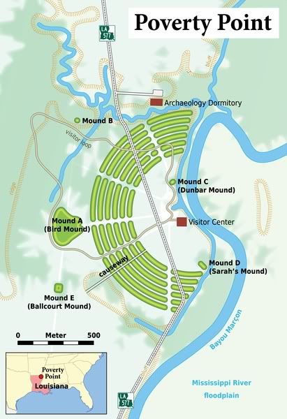
Upon arrival at Poverty Point, the sheer scale is the first thing that quietly overwhelms you. From ground level, it’s difficult to grasp the full design. This is where the visitor center’s aerial photographs and models become invaluable, revealing the breathtaking geometric precision of the site. Poverty Point consists of a series of six concentric, C-shaped earthen ridges, separated by ditches, which enclose a massive central plaza covering about 37 acres. Beyond these ridges, five large mounds punctuate the landscape, the most iconic being Mound A, often called the "Bird Effigy Mound," a colossal, T-shaped structure that, from above, resembles a bird in flight, its wings spanning nearly 640 feet.
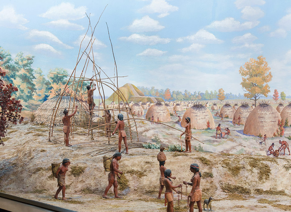
These aren’t natural formations. They are the result of an estimated five million hours of labor, moved basket by basket, scoop by scoop, by a highly organized hunter-gatherer society. No beasts of burden, no advanced tools – just human hands, ingenuity, and a collective vision. And this vision, this meticulous arrangement of earth, is their map.
Decoding the Ancient Native American Maps of Poverty Point
The "maps" of Poverty Point aren’t traditional navigational charts. Instead, they are multi-layered representations of knowledge, belief, and practical application, embedded directly into the landscape:

-
The Celestial Map: Aligning with the Cosmos
One of the most compelling interpretations of Poverty Point’s design is its function as a vast astronomical observatory – a map of the sky. The alignment of the mounds and ridges strongly suggests an intimate understanding of celestial cycles. Mound A, for instance, is oriented to the cardinal directions. Researchers have found compelling evidence that key points within the complex align with the summer and winter solstices and the equinoxes. Imagine standing in the central plaza, watching the sun rise or set precisely over a specific mound or along a particular ridge line on a significant day. This wasn’t accidental. It was a deliberate mapping of the sun’s journey, crucial for understanding seasons, predicting harvests (even for hunter-gatherers, resource availability changed seasonally), and perhaps for spiritual rituals marking the passage of time. The earthworks provided a tangible, immovable calendar, a cosmic clock that helped structure their lives and beliefs.
-
The Social & Ceremonial Map: Structuring Community
The concentric ridges themselves can be seen as a map of their social organization. It’s believed that thousands of people lived on these ridges, building their homes upon them. The distinct, tiered structure might reflect social hierarchy or clan divisions, with different groups occupying different sections. The central plaza, a vast open space, would have served as the focal point for gatherings, ceremonies, and trade – a communal map of interaction. This was a place where entire communities came together, where individual lives converged into a collective experience. The layout facilitated these interactions, guiding movement and defining spaces for various activities, from daily life to grand spiritual events. -

The Economic & Trade Network Map: Tracing Connections Across Ancient America
Perhaps one of the most astonishing aspects of Poverty Point, and a powerful demonstration of their "mapping" capabilities, is the evidence of extensive trade networks. The Poverty Point people were hunter-gatherers, yet artifacts found at the site reveal materials sourced from hundreds, even thousands, of miles away. Obsidian from the Ouachita Mountains of Arkansas, copper from the Great Lakes region, galena from Missouri, chert from Ohio, and soapstone from the Appalachians – these exotic materials traveled vast distances to reach this Mississippi Delta hub.How did they know where to find these materials? How did they navigate such immense distances? While no literal paper maps exist, the very presence and distribution of these artifacts are a map of their knowledge of the North American continent. They possessed an intricate mental map of resources, trade routes (likely riverine), and the communities that controlled these resources. Poverty Point itself, by becoming a major trade center, was a physical manifestation of this continent-wide economic map, a nodal point where goods, ideas, and people converged. It tells a story of an interconnected ancient world, far more complex than often imagined.
-
The Engineering & Surveying Map: Mastering the Land
The precision required to construct Poverty Point – the perfectly circular plaza, the parallel ridges, the specific orientations of the mounds – speaks volumes about their advanced understanding of surveying and engineering. They used sophisticated geometry, possibly employing plum bobs, sighting poles, and basic units of measurement to lay out this monumental complex. The site itself is a map of their technical capabilities, a demonstration of their ability to conceptualize and execute a grand design on an unprecedented scale. This wasn’t just digging; it was planned, measured, and meticulously executed, a testament to a collective mind that could envision and create on an epic scale.
Who Were These Master Mappers?
The people of Poverty Point existed during the Late Archaic period (around 1700 to 1100 BCE). They were not farmers, but rather highly skilled hunter-gatherers who thrived on the abundant resources of the Mississippi River floodplain – fish, deer, nuts, and waterfowl. Their ability to organize such massive construction projects without agriculture suggests an unusually rich resource base that allowed for a settled, large population and the leisure time to undertake such endeavors.
Their culture produced distinctive artifacts, including the enigmatic Poverty Point objects (PPOs) – small, baked clay balls believed to have been used as cooking stones in earth ovens, replacing natural stones which were scarce in the delta. They also crafted intricate effigy beads, plummets, and other tools, often from the exotic materials they acquired through trade. They were a people deeply connected to their environment, keenly observant of the natural world, and possessed a profound spiritual understanding that likely informed their monumental constructions.
Experiencing Poverty Point: Your Journey Through Time
Visiting Poverty Point today is an immersive journey into this ancient world. Your experience begins at the state-of-the-art Visitor Center, where interactive exhibits, detailed models, and compelling videos provide essential context for understanding the site. Seeing the aerial views and historical interpretations before stepping out onto the grounds is crucial for appreciating the true magnitude of what you’re about to witness.
From the Visitor Center, you have a few options to explore:
- Walking Trails: Several miles of paved and unpaved trails wind through the site, offering intimate views of the mounds and ridges. This allows for contemplation and a direct connection to the earthworks.
- Tram Tour: Highly recommended, especially for first-time visitors or on hot Louisiana days. The narrated tram tour takes you around the main circuit of the site, stopping at key points, providing historical insights, and helping you grasp the enormous scale. It’s the best way to get a sense of the distances and the overall layout without exhaustion.
- Driving Tour: You can also drive your own vehicle along the main loop, pulling off at designated stops for closer inspection.
As you traverse the site, take time to pause. Stand atop Mound A, let the vastness of the central plaza stretch before you, and try to imagine the bustling community that once thrived here. Feel the quiet power of the earth beneath your feet. The air might be thick with the humidity of Louisiana, but there’s an ethereal quality to the silence, broken only by the chirping of birds – a sound that would have been familiar to the people who built this place.
Why Poverty Point Matters Today
Poverty Point isn’t just a historical curiosity; it’s a vital piece of the human story. Its designation as a UNESCO World Heritage Site places it alongside wonders like the Great Wall of China and the Pyramids of Giza, acknowledging its universal value. It challenges simplistic narratives of pre-Columbian North America, demonstrating that complex societies, monumental architecture, and sophisticated astronomical and engineering knowledge existed here long before European contact.
For the modern traveler, Poverty Point offers a unique opportunity to connect with a profound human legacy. It invites us to consider what "mapping" truly means – not just drawing lines on a page, but understanding, organizing, and expressing one’s relationship with the land, the sky, and fellow human beings. It’s a reminder of human ingenuity, collective effort, and the enduring quest to comprehend our place in the universe.
So, when you plan your next adventure, consider a journey to Poverty Point. Come prepared to walk, to imagine, and to be profoundly moved. You won’t just be visiting an ancient site; you’ll be stepping into a living map, deciphering the wisdom of those who first charted their world in the very soil beneath your feet. It’s a journey that will not only broaden your understanding of history but also deepen your appreciation for the incredible capabilities of the human spirit.

