Unearthing Ancestral Echoes: A Chumash Journey Along the Santa Barbara Channel Coast
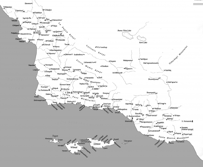
Forget static lines on ancient parchment; the true Chumash historical map of coastal settlements isn’t a document you hold in your hand, but a living, breathing landscape. It’s etched into the very bluffs, sung by the ocean waves, and whispered by the wind through the sycamores. For the traveler seeking a profound connection to California’s deep past, a journey along the Santa Barbara Channel Coast isn’t just a scenic drive; it’s an immersive review of a territory where every turn reveals a layer of history, a former village, a sacred site, and the enduring legacy of the Chumash people.
My recent exploration of this stretch, from Ventura to Point Conception, wasn’t merely about ticking off landmarks. It was about learning to read the land as the Chumash did, understanding how their sophisticated society thrived for millennia on the abundant resources of the land and sea. This isn’t just a beautiful destination; it’s an open-air museum, a vibrant cultural landscape, and a testament to resilience.
Syukhtun: The Heartbeat of a Thriving Civilization (Modern Santa Barbara)

Our journey begins, conceptually, at Syukhtun, the largest and most influential Chumash village in the region, now largely overlaid by modern Santa Barbara, particularly around Stearns Wharf and the adjacent beaches. To review this location through a Chumash lens is to see beyond the bustling pier and sunbathers. Stand at the end of Stearns Wharf, gaze out at the Santa Barbara Channel, and imagine. This was the hub of a vast maritime empire.
The waters teemed with marine life – fish, shellfish, seals, and dolphins – providing sustenance. The land behind you, now built up, once offered acorns from oak groves, seeds, and game. This wasn’t just a fishing village; it was a major trading port. The Chumash were master boat builders, crafting the plank canoe known as the tomol. These remarkable vessels, sealed with asphaltum (a natural tar found in the area), allowed them to navigate the often-treacherous channel, trading with the island Chumash (Cruzeño, Isleño, Liseño) and other mainland groups.
Walking along Shoreline Park, you’re traversing the very ground where countless generations lived, worked, and worshipped. While no visible village structures remain, the strategic location – sheltered bay, access to fresh water, proximity to resources – is self-evident. The flat, fertile lands behind the beach were ideal for settlements, while the adjacent hills offered defensive positions and views. It’s a review not of what is visibly there, but of what the landscape dictates was there, and why it thrived. The energy of a major center still feels palpable, a testament to its enduring significance.
The Bluffs and Estuaries: Resource Richness and Strategic Vantage Points

Moving west or east from Syukhtun, the coastal bluffs and estuaries reveal more about the Chumash "map." Places like Douglas Family Preserve (often called Hendry’s Beach Mesa) offer breathtaking panoramic views of the channel. For the Chumash, these elevated positions were critical. They provided strategic oversight for spotting incoming tomols, observing marine activity, and monitoring the surrounding landscape. Imagine Chumash lookouts scanning the horizon, perhaps spotting the distinctive profile of an island tomol laden with obsidian or shell beads.
Further along, the Carpinteria Salt Marsh Nature Park and the Goleta Slough (near the Santa Barbara Airport) are crucial pieces of this historical map. These estuaries, though now significantly altered, were once incredibly rich ecosystems. They provided calm, sheltered waters for fishing, vast quantities of shellfish, waterfowl, and reeds for basketry and construction. The Chumash managed these resources meticulously, employing sophisticated ecological knowledge to ensure sustained abundance. A review of these areas today requires imagination to strip away modern development and visualize them as thriving Chumash pantry and workshop. Interpretive signs in places like the Carpinteria Salt Marsh offer glimpses into this past, educating visitors on the native plants and their traditional uses.
The Channel Islands: The Spiritual and Economic Heartline
No review of Chumash coastal settlements is complete without acknowledging the Channel Islands National Park. While not "coastal settlements" in the mainland sense, these islands (especially Santa Cruz, Santa Rosa, and San Miguel) were home to distinct Chumash communities for over 10,000 years. Their connection to the mainland Chumash was profound, forming an integrated economic and spiritual network.

Visiting the Channel Islands (a boat trip from Ventura or Santa Barbara is required) is perhaps the most immersive way to connect with the Chumash maritime legacy. Stepping onto the shores of Santa Cruz Island, you’re walking on land where generations of islanders lived. You can see the remnants of ancient shell middens – refuse piles that are archaeological goldmines, revealing diets, tools, and daily life. The island Chumash were particularly skilled in creating shell beads, which served as currency across much of California.
The journey across the channel itself is a powerful experience. As your boat cuts through the waves, you gain a visceral understanding of the challenges and triumphs of tomol travel. Imagine making that journey without modern navigation, relying on ancestral knowledge of currents, stars, and landmarks. The islands were not just homes; they were sacred places, often shrouded in fog and mystery, holding deep spiritual significance for all Chumash. This segment of the journey is not just a review of a beautiful national park; it’s a profound encounter with the very soul of Chumash civilization.
Interpreting the Map: Cultural Sites and Modern Voices
While much of the Chumash "map" is read through the landscape, modern institutions and the ongoing presence of the Chumash people provide vital interpretation.
The Santa Barbara Museum of Natural History is an indispensable resource. Its "Chumash Life" exhibit offers a detailed and respectful portrayal of Chumash culture, showcasing artifacts, tomol replicas, basketry, tools, and spiritual practices. It helps to contextualize what you’ve seen (or imagined) on the coast, providing a tangible link to the past. This museum acts as a crucial guide, explaining the sophisticated astronomy, the intricate trade networks, and the profound connection to the land and sea that defined Chumash life.
Beyond institutions, the contemporary Chumash community is a living testament to resilience. Organizations like the Santa Ynez Band of Chumash Indians are actively working to preserve and revitalize their language, traditions, and sacred sites. While direct access to all sacred sites may be restricted out of respect, supporting their cultural initiatives, attending public events, or simply learning about their ongoing presence is a critical part of a respectful review of this historical landscape. Look for interpretive signs, often developed in partnership with tribal elders, which offer indigenous perspectives on the places you visit.

The Enduring Map: A Call for Respectful Exploration
The Chumash historical maps of coastal settlements aren’t just about tracing ancient village locations. They are about understanding a way of life intrinsically linked to the land and sea. They reveal a people who understood sustainability long before the concept was popularized, who built a thriving society based on ingenuity, community, and deep spiritual reverence for their environment.
As a travel destination, the Santa Barbara Channel Coast offers more than just stunning views and pristine beaches. It offers a chance to engage with a profound and enduring history. My review of this location is overwhelmingly positive, not just for its natural beauty, but for the depth of historical and cultural immersion it provides.
For the mindful traveler:
- Walk with awareness: Every step along these beaches, bluffs, and estuaries is on ancestral land.
- Support local institutions: Visit the Santa Barbara Museum of Natural History and other educational centers.
- Respect the land: Practice Leave No Trace principles diligently.
- Seek out contemporary Chumash voices: Learn about their ongoing efforts to preserve their heritage.
- Imagine: Allow yourself to visualize the landscape as it once was, teeming with tomols, bustling villages, and a vibrant indigenous culture.
This journey along the Santa Barbara Channel Coast is not just a trip through picturesque scenery; it’s an invitation to step onto a living map, to listen to the echoes of millennia, and to gain a deeper appreciation for the original stewards of this remarkable land. It’s a travel experience that stays with you, reminding you that history isn’t just in books; it’s in the very ground beneath your feet.

