Forget static maps and one-dimensional histories. For the discerning traveler, understanding a destination goes far beyond sightseeing; it demands a deep dive into its true narrative, its foundational stories, and the peoples who have shaped its lands for millennia. Nowhere is this more powerfully illuminated than through the interactive land-use maps of the Sioux Nation. These aren’t just navigational tools; they are dynamic portals into Indigenous sovereignty, historical truth, and a profound re-education about the very ground beneath our feet. This review explores why these interactive maps are not merely a useful resource, but an indispensable lens for anyone seeking to engage respectfully and meaningfully with the ancestral territories of the Očhéthi Šakówiŋ.
The Foundation: What Are Interactive Sioux Nation Land Use Maps?
At their core, interactive Sioux Nation land-use maps are sophisticated digital tools leveraging Geographic Information Systems (GIS) technology to visualize and present the complex, multifaceted history and contemporary realities of Sioux territories. Unlike conventional maps, which often present a simplified, colonial-centric view of geography, these interactive platforms are designed to:
- Restore Indigenous Perspectives: They prioritize and present the land from the viewpoint of the Lakota, Dakota, and Nakota peoples, emphasizing their traditional ecological knowledge, spiritual connections, and historical land-management practices.
- Detail Historical Land Tenure: These maps meticulously document pre-colonial territorial boundaries, vital hunting grounds, sacred sites, migration routes, and the devastating impact of treaties, forced removals, and reservation allocations.
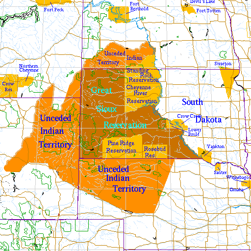
- Illustrate Treaty Violations: Crucially, many maps explicitly overlay historical treaty boundaries with subsequent land cessions and modern reservation lines, powerfully illustrating the systemic erosion of Indigenous land rights and the ongoing legacy of broken promises.
- Show Contemporary Land Use: They often include layers depicting current reservation lands, tribal parks, conservation areas, economic development zones, and community infrastructure, providing a holistic view of modern Indigenous stewardship and self-determination.
- Integrate Multimedia: Beyond lines and polygons, these maps often embed rich multimedia content – oral histories, archival photographs, traditional place names (toponymy), cultural narratives, and even contemporary interviews – transforming a geographical tool into a living, breathing archive of cultural heritage.


These maps are typically developed through collaborative efforts between tribal governments, cultural institutions, Indigenous scholars, and academic partners. They are often open-source or publicly accessible, making this vital knowledge available to a global audience.
Decolonizing the Map: Why Perspective Matters

The most significant impact of these interactive maps lies in their ability to decolonize our understanding of North American geography. For centuries, maps have been instruments of colonial power, erasing Indigenous presence, renaming ancestral lands, and delineating arbitrary borders that ignored existing Indigenous nations. These interactive Sioux Nation maps directly challenge this paradigm by:
- Reasserting Indigenous Toponymy: They reintroduce and prioritize the original Lakota, Dakota, and Nakota names for mountains, rivers, and significant places, connecting users to the profound cultural and spiritual significance embedded in these names. This is not merely a linguistic exercise; it’s an act of cultural reclamation and an invitation to see the landscape through an Indigenous worldview.
- Visualizing Sovereignty: By clearly depicting the vast extent of pre-treaty Sioux lands (e.g., the Great Sioux Reservation established by the 1868 Fort Laramie Treaty) and then layering subsequent reductions, the maps offer a stark visual representation of Indigenous sovereignty and its systematic diminishment. This visualization is critical for understanding ongoing land claims, legal battles, and the "Land Back" movement.
- Connecting People to Place: Traditional Sioux land use was inextricably linked to the environment – the buffalo migration routes, sacred Black Hills, Paha Sapa, the Missouri River, and fertile hunting grounds. These maps vividly illustrate these connections, demonstrating how Indigenous cultures are rooted in specific geographies and how the loss of land equates to the loss of cultural practice, language, and spiritual connection.
- Challenging the "Empty Wilderness" Myth: They dismantle the colonial myth of an untouched wilderness awaiting European settlement. Instead, they showcase vibrant, managed landscapes, rich in cultural significance and teeming with human activity for thousands of years. This reframes the entire narrative of American history, placing Indigenous peoples at the center of the story.

Key Features and Interactivity for the Engaged Traveler
For the travel blogger and their audience, the interactive nature of these maps unlocks a unique level of engagement and understanding:
- Layer Management: Users can toggle various layers on and off, allowing for customized exploration. Want to see only sacred sites? Or perhaps overlay historical buffalo ranges with modern reservation boundaries? The flexibility allows for targeted learning. This feature is invaluable for planning a trip, as it helps identify areas of particular cultural significance or contemporary Indigenous community activity.
- Dynamic Timelines: Many platforms incorporate a timeline feature, allowing users to scroll through different historical periods. Watching the Great Sioux Reservation shrink decade by decade, or seeing the shift in buffalo migration patterns over centuries, offers a profound and emotionally resonant historical lesson that static maps simply cannot convey.
- Multimedia Hotspots: Clicking on specific locations often reveals pop-up windows with embedded information: a recording of an elder sharing an oral history about a sacred site, a photograph of a historical event, a video explaining traditional hunting practices, or text detailing a specific treaty clause. This deep contextualization moves beyond mere geography into rich cultural immersion.
- Search and Filter Functions: Travelers can search for specific places, historical events, or cultural categories (e.g., "sacred sites," "battlefields," "Lakota communities"). This facilitates research and allows for personalized itineraries based on areas of interest.
- Accessibility and User Experience: The best interactive maps are designed with intuitive interfaces, making them accessible even to those without prior GIS experience. Clear legends, easy navigation, and responsive design ensure a smooth and engaging user journey. This ease of use encourages broader engagement and deeper learning.
Indispensable for the Ethical Traveler
For the conscious traveler aiming for more than just a surface-level experience, these interactive Sioux Nation maps are an indispensable tool. They directly address several core tenets of ethical and responsible tourism:
- Pre-Trip Education: Before setting foot on Indigenous lands, understanding the historical and contemporary context is paramount. These maps provide a robust educational foundation, preparing travelers to engage respectfully and avoid unintentional cultural missteps. Knowing the traditional names of places, the significance of certain landmarks, or the history of a particular community enhances appreciation and reduces the likelihood of cultural insensitivity.
- Respecting Sovereignty: By visualizing tribal boundaries and treaty lands, travelers gain a clearer understanding of Indigenous sovereignty. This knowledge informs interactions with tribal communities, fosters respect for tribal laws and customs, and encourages visitors to support tribal businesses and initiatives directly.
- Deeper Cultural Immersion: Instead of viewing a landscape as mere scenery, these maps transform it into a living tapestry of history, culture, and spirituality. A drive through the Black Hills becomes infinitely more meaningful when you understand its sacred significance to the Lakota people, its role in their origin stories, and the ongoing struggle for its return.
- Identifying Indigenous-Led Experiences: Many maps highlight tribal parks, cultural centers, museums, and community events. This allows travelers to seek out and support authentic, Indigenous-led tourism experiences, ensuring that their travel dollars directly benefit the communities whose lands they are visiting.
- Challenging Assumptions: These maps are powerful tools for deconstructing preconceived notions about Indigenous peoples. They reveal resilience, continuous cultural practice, and sophisticated land stewardship, moving beyond outdated stereotypes.
Beyond Travel: Education and Preservation
While invaluable for travelers, the impact of these interactive Sioux Nation land-use maps extends far beyond tourism. They serve as critical resources for:
- Indigenous Communities: For younger generations, these maps are vital educational tools, connecting them to their ancestral lands, histories, and languages. They aid in cultural revitalization efforts, land management, and asserting inherent rights.
- Academics and Researchers: They provide robust data and visual evidence for studies in history, anthropology, environmental science, and Indigenous studies, offering rich primary source material and new avenues for inquiry.
- Advocacy and Policy: The clear visualization of treaty boundaries and land dispossession strengthens arguments for treaty rights, environmental justice, and land reparations, providing undeniable evidence for policy makers and legal teams.
- Public Awareness: For the general public, these maps are powerful instruments of education, fostering empathy, challenging dominant narratives, and promoting a more accurate and equitable understanding of North American history.
Navigating the Digital Landscape: Considerations and Support
While transformative, engaging with these interactive maps also comes with considerations:
- Data Sovereignty and Access: Travelers should be aware that not all Indigenous data is meant for unrestricted public access. Respecting data sovereignty means understanding that some information may be protected or limited to tribal members for cultural preservation reasons. The most ethical maps will clearly delineate public vs. restricted information.
- Funding and Sustainability: Developing and maintaining these complex digital platforms requires significant resources. Supporting Indigenous-led initiatives, whether through direct donations, purchasing related educational materials, or advocating for funding, is crucial for their long-term viability.
- Continuous Evolution: These maps are living documents, continually updated with new research, community input, and technological advancements. What you see today may evolve tomorrow, reflecting the dynamic nature of Indigenous knowledge and ongoing struggles.
Conclusion: A New Compass for Understanding
Interactive Sioux Nation land-use maps represent a monumental shift in how we understand geography, history, and culture. They are more than just a collection of digital layers; they are acts of Indigenous self-determination, educational imperatives, and powerful tools for decolonization. For the traveler, they offer a profound opportunity to move beyond the superficial, to engage with a destination not just as a place on a map, but as a living landscape imbued with millennia of Indigenous presence, wisdom, and resilience.
To truly travel consciously within the ancestral lands of the Očhéthi Šakówiŋ is to understand the stories etched into its rivers, mountains, and plains. These interactive maps provide the compass, the guide, and the narrative framework for that journey. They challenge us to listen, to learn, and to witness the enduring spirit of a people intricately woven into the fabric of their homeland. Seek them out, explore them deeply, and let them transform your understanding of the world. Your travels, and your perspective, will be immeasurably richer for it.
