Dominica: Where Ancient Maps Whisper in the Rainforest – A Journey into the Living Kalinago Territory
Forget the pristine, manicured resorts and predictable tourist trails. If your wanderlust yearns for a journey that transcends mere sightseeing, one that delves into the very soul of the Caribbean, then Dominica awaits. This isn’t just an island; it’s a vibrant, breathing testament to resilience, culture, and a history etched not just on parchment, but into the very landscape. For the traveler intrigued by the concept of Caribbean indigenous territory maps, Dominica offers an unparalleled, immersive experience where those historical lines on paper spring to life.
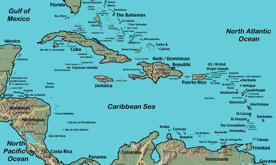
My recent journey to Dominica, often called "The Nature Island," was less about conquering peaks and more about understanding roots. It was a quest to see how the historical claims and territories of the Caribbean’s first peoples – specifically the Kalinago (formerly known as Caribs) – translate into a tangible, living experience today. What I found was profound: the Kalinago Territory, a designated 3,700-acre district on Dominica’s eastern coast, isn’t just a dot on a modern map; it’s a pulsating heart, an open book, and a powerful living monument to an enduring culture.
The Kalinago Territory: Where the Map Lives and Breathes

Stepping into the Kalinago Territory, officially established in 1903, is like crossing a threshold into a different time, yet one that is vibrantly contemporary. This is the last remaining legally recognized indigenous territory in the Caribbean, a direct and powerful echo of the ancestral lands depicted on those old European maps, which often dismissed or demonized the "Caribs." Here, the Kalinago people maintain their distinct identity, language fragments, craft traditions, and a deep, symbiotic relationship with their environment.
The concept of "indigenous territory maps" often conjures images of static historical documents. In Dominica, it’s anything but. The territory is a dynamic space, a patchwork of small villages like Salybia, Sineku, and Crayfish River, nestled amidst steep hills and lush valleys, all overlooking the tumultuous Atlantic. The boundaries aren’t just lines; they are marked by the flow of rivers, the rise of mountains, and the collective memory of a people who resisted colonial erasure for centuries.
Our exploration began at the Kalinago Barana Autê, a cultural village designed to showcase Kalinago heritage. It’s more than a museum; it’s an interactive journey. Guides, themselves Kalinago, explain their history, from their migration from South America to their fierce defense against European encroachment. They demonstrate traditional canoe building – a skill that speaks volumes about their maritime prowess and ancient trade routes, routes that would have been meticulously mapped in their minds long before any European cartographer arrived. We witnessed the intricate weaving of larouma reed baskets, a craft passed down through generations, each pattern telling a story. We tasted cassava bread, a staple for millennia, prepared on a traditional griddle, connecting us directly to their ancestral diet.
But the real magic happens beyond the structured tour. Walking through the territory, you feel the weight of history in the rustling leaves and the crashing waves. Every plant, every rock, every bend in the river has significance. The guide might point out a particular tree used for medicine, or a specific fruit that has sustained their community for centuries. This isn’t just nature; it’s a living larder, a pharmacy, and a spiritual sanctuary, all mapped out in the traditional knowledge of the Kalinago people. The "map" here is not just a visual representation of land ownership, but an intricate web of ecological understanding and cultural practice.

Beyond the Borders: Kalinago Footprints Across the Island
While the Kalinago Territory is the most prominent living example, the indigenous legacy of Dominica extends far beyond its designated borders. The island’s very name, "Waitukubuli" in Kalinago, speaks of its pre-colonial identity, a name that means "tall is her body," aptly describing its mountainous spine. Everywhere you look, especially in the interior, you find echoes of their presence.
Consider the place names: Layou, Marigot, Canefield, Colihaut – many are derived from Kalinago words, silently reminding visitors of who lived here first. The winding rivers and dramatic waterfalls, like Trafalgar Falls or the Emerald Pool, were not just scenic spots but vital resources and spiritual sites for the Kalinago. Their deep understanding of the island’s unique volcanic geology and abundant flora and fauna shaped their survival and culture.
Hiking through Dominica’s dense rainforests, often considered some of the most pristine in the Caribbean, you walk paths that have likely been trodden for centuries. These aren’t just hiking trails; they are ancient arteries connecting villages, hunting grounds, and sacred spaces. The very concept of navigating this rugged terrain, using natural landmarks and an intimate knowledge of the environment, is an act of living cartography, a human map overlaid on the natural one. The map of their territory was never just a flat drawing; it was a three-dimensional, sensory experience of their home.

Dominica’s Landscape: A Living Cartography
Dominica itself feels like a living, breathing map of ancient times. Its dramatic volcanic peaks, over 365 rivers (one for each day of the year), and untouched rainforests are a stark contrast to many of its more developed neighbors. This ruggedness, which made it less appealing to large-scale plantation agriculture, ironically helped preserve its natural beauty and, crucially, provided a natural fortress for the Kalinago people.
The island’s geothermal activity, evident in its bubbling mud pools and hot springs like Titou Gorge or the Boiling Lake (a challenging but rewarding hike), are not just geological wonders. For the Kalinago, these were parts of their natural world, possibly holding spiritual significance or practical uses. To understand Dominica is to understand its geology, and to understand its geology through an indigenous lens is to appreciate how these powerful natural features shaped settlement patterns, resource gathering, and cultural narratives. The island’s contours, its peaks and valleys, are the ultimate indigenous territory map, drawn by nature and interpreted by its first inhabitants.
The Deeper Meaning of Travel Here
Traveling to Dominica, particularly with an awareness of its indigenous heritage, is not a passive vacation; it’s an education. It’s an opportunity to challenge the often Eurocentric narratives of Caribbean history and to engage with a living culture that defied extinction. It’s about recognizing the profound connection between people and place, a connection that goes far beyond property deeds and political boundaries.
For those interested in "Caribbean indigenous territory maps," Dominica offers the chance to move beyond the abstract. It allows you to walk the land, hear the stories, and feel the spirit of a people whose territory was defined by their knowledge of the land, their cultural practices, and their enduring presence, long before colonial powers ever attempted to draw lines on paper. It encourages responsible tourism, where visitors are guests, learners, and supporters of cultural preservation.

It’s a place that forces you to reflect on what "territory" truly means. Is it merely a geographical area, or is it a space imbued with history, memory, and identity? In Dominica, it is undeniably the latter. The Kalinago Territory stands as a powerful symbol of self-determination, a place where an ancient map has been redrawn, not by colonial powers, but by the persistent spirit of its original inhabitants.
Practical Travel Tips for the Conscious Explorer:
- Getting There: Dominica has two airports (Douglas-Charles Airport, DOM, and Canefield Airport, DCF). International flights usually connect through other Caribbean hubs like Barbados, Antigua, or Puerto Rico.
- When to Go: The dry season (February to May) offers pleasant weather. The wet season (June to November) brings lushness but also the possibility of hurricanes.
- Accommodation: Focus on eco-lodges, guesthouses, and boutique hotels that emphasize sustainability and cultural sensitivity. Look for options near the Kalinago Territory or in the capital, Roseau, which provides a good base for island exploration.
- Getting Around: Renting a 4×4 vehicle is highly recommended due to Dominica’s mountainous terrain and sometimes challenging roads. Taxis and local minibuses are also available.
- Exploring the Kalinago Territory: Arrange a guided tour through the Kalinago Barana Autê. Engage with local artisans directly, respectfully ask questions, and purchase their crafts to support the community. Always ask for permission before taking photographs of people.
- Must-Do Activities:
- Visit the Kalinago Barana Autê for cultural immersion.
- Hike to the Boiling Lake (a challenging full-day trek).
- Swim in the refreshing waters of Trafalgar Falls, Emerald Pool, or Ti Kwen Glo Cho.
- Explore the vibrant markets of Roseau.
- Go canyoning or river tubing for an adrenaline rush.
- Take a boat trip to watch sperm whales, which frequent Dominica’s waters.
- Cuisine: Savor traditional Kalinago dishes, fresh seafood, and the abundance of local fruits and vegetables. Try "callaloo" soup, grilled fish, and ground provisions like dasheen, yam, and plantain.
- Respectful Engagement: Remember you are a guest. Be open to learning, respect local customs, and support the local economy directly.
Dominica is more than just a destination; it’s a profound experience. It’s a place where the lines on ancient maps dissolve into the vibrant green of the rainforest, where history is not just read but felt, and where the enduring spirit of the Caribbean’s indigenous people offers a powerful, humbling lesson in resilience and cultural pride. This is a journey that will not only fill your passport with stamps but also enrich your understanding of our shared human story.
