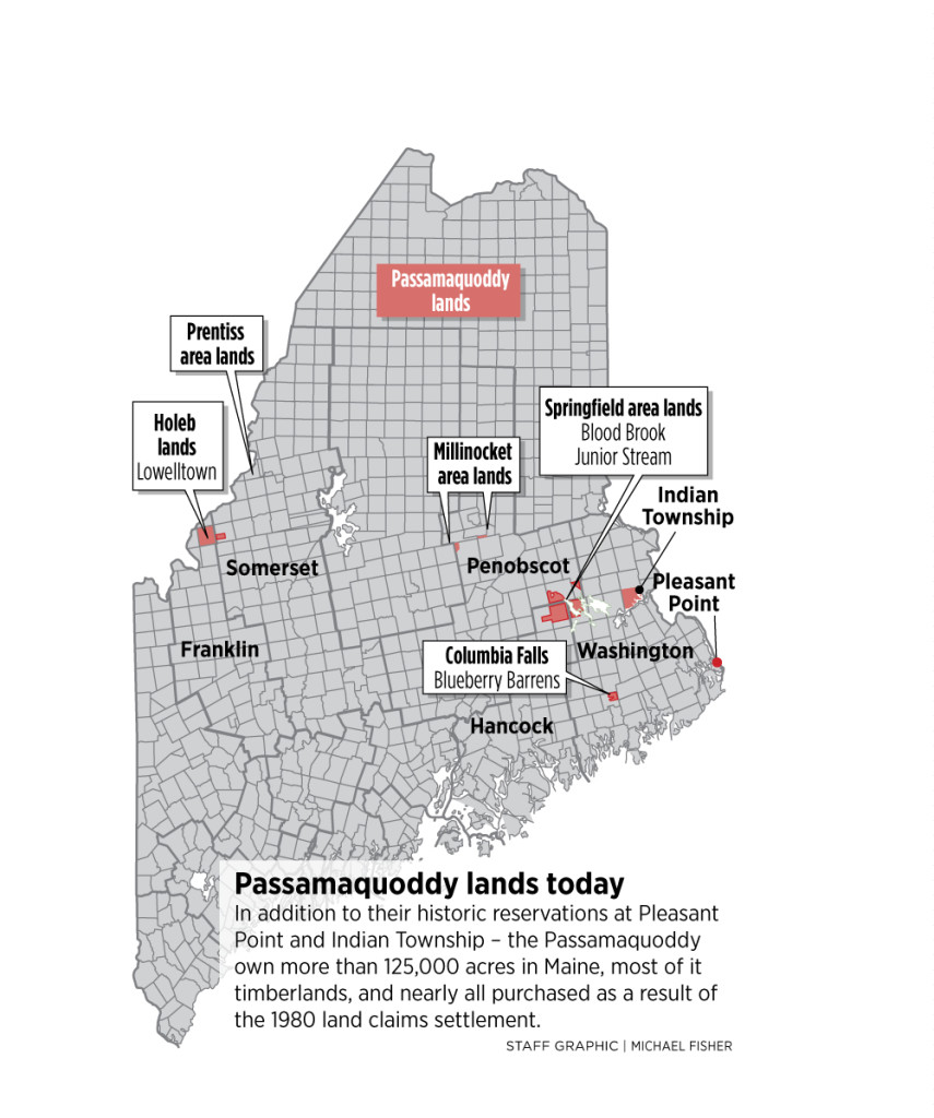
The easternmost tip of the United States, a dramatic promontory of rugged cliffs and ancient spruce forests, is not merely a geographic marker; it is a profound landscape steeped in the enduring spirit of the Peskotomuhkati Nation, the Passamaquoddy people. This is the heart of their ancestral lands, a territory stretching across the St. Croix River watershed and the magnificent Passamaquoddy Bay, connecting what are now Maine and New Brunswick. To visit places like Quoddy Head State Park and the surrounding coastline is to walk on land that has nurtured a vibrant culture for millennia, a place where every crashing wave and whispering pine tells a story far older than any lighthouse.
My journey to this remote corner of Washington County, Maine, wasn’t just about ticking off a bucket list item – the iconic red and white striped West Quoddy Head Light. It was an immersion into a landscape that felt alive with history, a place where the present moment of natural beauty is undeniably woven with a deep past. Arriving at Quoddy Head, the first thing that strikes you is the sheer scale of the ocean, a vast, churning expanse that meets the land with an untamed power. The air is crisp, carrying the scent of salt and pine, and the constant roar of the Atlantic provides a primal soundtrack.
The lighthouse itself, perched precariously on 85-foot cliffs, is a beacon of both maritime history and natural wonder. Its candy-cane stripes stand in stark contrast to the deep green of the surrounding forest and the tumultuous blues and grays of the ocean. From its vantage point, the views are simply breathtaking. To the east, across the restless waters of the Bay of Fundy, lie the shores of Grand Manan Island in New Brunswick, Canada. This international boundary, however, is a modern construct; for the Peskotomuhkati, these waters were a highway, a source of sustenance, and a sacred space connecting communities. They are part of the larger Wabanaki Confederacy, a powerful alliance of Indigenous nations whose territories span much of what is now New England and the Maritimes.
Venturing beyond the immediate vicinity of the lighthouse, the Coastal Trail beckons. This well-maintained path winds along the clifftops, offering continuous panoramic views of the raw, unspoiled coastline. Each turn reveals a new vista: dramatic sea stacks carved by relentless erosion, hidden coves where seals occasionally bask, and dense groves of spruce and fir trees clinging to the rocky terrain. The geology here is a story in itself, ancient layers of rock folded and uplifted, bearing witness to millions of years of Earth’s transformations.

But to truly experience this land, one must look beyond the immediate visual spectacle and listen to the deeper narrative. Imagine the Passamaquoddy people, the "people of the pollock," navigating these very waters in their birchbark canoes, their knowledge of the tides, currents, and marine life honed over countless generations. This was their pantry, their highway, their spiritual sanctuary. The rich fisheries of Passamaquoddy Bay – teeming with pollock, cod, herring, and lobster – provided the sustenance that allowed their culture to thrive. The forests offered shelter, game, and materials for their sophisticated crafts. The land itself was not merely a resource but a living relative, imbued with spirit and deserving of profound respect and stewardship.
Walking these trails, I found myself pausing frequently, not just to admire the view, but to connect with this sense of enduring presence. One can almost hear the echoes of ancient ceremonies, the rhythm of paddles dipping into the waves, the laughter of children playing by the shore. The Passamaquoddy lived in harmony with the cycles of nature, understanding the intricate balance of the ecosystem in a way that modern society is only now beginning to relearn. Their understanding of "Passamaquoddy Time" – a natural rhythm dictated by the tides, the seasons, and the movements of the sun and moon – is a powerful counterpoint to our hurried modern pace.
The unique tidal phenomena of the region are another testament to its vibrant natural energy. Passamaquoddy Bay is at the mouth of the Bay of Fundy, which boasts the highest tides in the world. This dramatic ebb and flow shapes the entire ecosystem, creating a dynamic environment that supports an incredible diversity of marine life. During low tide, vast mudflats are exposed, revealing a treasure trove for shorebirds and offering a glimpse into the hidden world beneath the waves. This constant movement of water also creates strong currents, which the Passamaquoddy expertly navigated for fishing and travel.
Beyond Quoddy Head, the exploration of this ancestral land continues. Just a short drive away lies Cobscook Bay State Park, a less dramatic but equally beautiful landscape of tidal flats, islands, and intricate shorelines. "Cobscook" itself is derived from the Passamaquoddy term "kabiskat," meaning "where the waters boil," a reference to the powerful tidal currents. Here, the focus shifts from rugged cliffs to more sheltered coves, offering different perspectives on the same magnificent body of water. Kayaking or canoeing in Cobscook Bay, especially during the calmer parts of the tidal cycle, offers an intimate connection to the water, allowing one to observe seals, porpoises, and a myriad of seabirds in their natural habitat. Bald eagles are a common sight, soaring overhead, embodying the wild spirit of this place.

The towns that dot this coastline, like Lubec, Cutler, and Eastport, while having their own rich maritime histories, are built upon and exist within this ancient territory. Their economies, historically tied to fishing and lumber, are modern iterations of the resource utilization that defined Passamaquoddy life for millennia. Engaging with local businesses and communities provides a contemporary lens through which to appreciate the ongoing relationship between people and this land.
For the traveler, a visit to this region requires more than just a camera; it demands an open mind and a respectful heart. This isn’t just a picturesque destination; it’s a living landscape with a profound cultural heritage. Learning about the Passamaquoddy people, their history, their language (Peskotomuhkatiyemowak), and their ongoing efforts to preserve their culture and lands, enriches the travel experience immeasurably. Resources like the Abbe Museum in Bar Harbor, while not directly on Passamaquoddy land, offer excellent insights into Wabanaki culture, and local visitor centers often have information on regional Indigenous history.
Practical Travel Tips for a Respectful and Enriching Visit:
- Best Time to Visit: Late spring through early fall offers the most comfortable weather for hiking and exploring. Summers are generally mild and beautiful, though can be foggy. Fall foliage is spectacular, but be prepared for cooler temperatures and potentially strong winds. Winter can be starkly beautiful but challenging due to weather and limited services.
- What to Bring: Layers of clothing are essential, as coastal weather can change rapidly. Sturdy hiking shoes are a must for the trails. Binoculars are highly recommended for wildlife viewing (birds, seals, whales). Don’t forget bug spray, especially in wooded areas during warmer months.
- Respect the Land: Practice Leave No Trace principles. Stay on marked trails to protect fragile ecosystems. Remember that this land has cultural significance; approach it with respect and reverence.
- Engage Locally: Support local businesses, from restaurants to craft shops. Many locals are knowledgeable about the area’s history and natural features.
- Learn More: Seek out information on the Passamaquoddy Nation. Understanding their history and ongoing presence here adds immeasurable depth to your visit.
- Accessibility: While the lighthouse area itself is generally accessible, some of the coastal trails can be uneven and challenging for those with mobility issues. Check individual park websites for specific accessibility information.


In conclusion, the ancestral lands of the Passamaquoddy, particularly around Quoddy Head and Passamaquoddy Bay, offer a travel experience unlike any other. It is a place where the raw, untamed beauty of the Maine coast converges with a deep, resonant cultural history. It’s a journey not just to the edge of a continent, but into the heart of an enduring legacy. The sweeping vistas, the roaring ocean, the ancient forests – all whisper tales of resilience, stewardship, and a profound connection to the land that has sustained a people for millennia. To stand at the easternmost point of the U.S. and gaze out at the vast Atlantic is to witness the sunrise not just on a new day, but on a timeless landscape, forever imprinted with the spirit of the Peskotomuhkati Nation. It’s an invitation to pause, reflect, and appreciate the layers of history, nature, and culture that make this corner of the world truly extraordinary.
