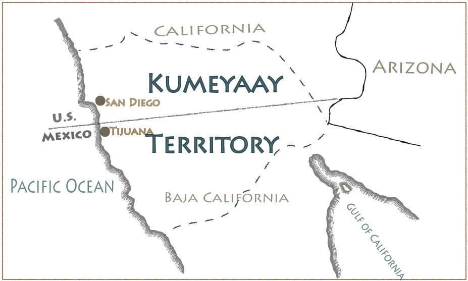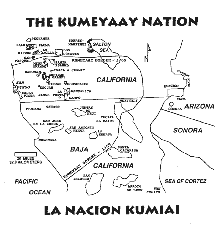
The Kumeyaay Nation’s traditional territory map is far more than a geographical delineation; it is a living document, an ancestral memory, and a powerful statement of identity and resilience etched across the landscapes of Southern California and Baja California. For any traveler or history enthusiast seeking a deeper understanding of this vibrant region, comprehending this map is essential, revealing layers of history and culture beneath the modern veneer of cities, freeways, and international borders.
Mapping an Ancient Homeland: The Kumeyaay Domain
The traditional Kumeyaay territory stretches from the Pacific Ocean, encompassing much of present-day San Diego County, east into the Anza-Borrego Desert, and south deep into Baja California, Mexico. Its northern boundary generally extends to near present-day Oceanside and Escondido, while its southern reaches historically extended past Ensenada in Baja California. This vast and ecologically diverse land, which the Kumeyaay have inhabited for at least 12,000 years, includes coastal plains, chaparral-covered hills, mountain ranges (like the Laguna Mountains and Cuyamaca Mountains), and arid desert environments.
This expansive territory was not a monolithic entity but rather a network of interconnected Kumeyaay bands, often referred to by their linguistic variations: the Ipai (northern Kumeyaay) and Tipai (southern Kumeyaay), or historically, collectively as Diegueño by the Spanish. Despite these internal distinctions, a shared language, cultural practices, and an intricate web of kinship and trade routes bound them together. The map, therefore, represents a homeland defined by shared ancestry, sacred sites, resource management, and a profound spiritual connection to every mountain, river, and coastline within its bounds.

A Lifeway Shaped by the Land
Prior to European contact, the Kumeyaay lived a sophisticated semi-nomadic lifestyle, meticulously adapting to and managing their diverse environment. Their territory provided an abundance of resources: the ocean yielded fish, shellfish, and marine mammals; coastal and inland areas offered acorns (a dietary staple), seeds, berries, and game like deer, rabbit, and quail. The desert provided unique plant resources and hunting opportunities, utilized through seasonal migrations.
The traditional map is thus a guide to these ancient lifeways. It marks the locations of seasonal camps, permanent villages, sacred ceremonial sites, petroglyphs, burial grounds, and the intricate network of trails that connected them. These trails were not just pathways for travel but conduits for trade, communication, and the sharing of cultural knowledge. Every peak, valley, and water source held a name in the Kumeyaay language, imbued with stories, history, and spiritual significance. Understanding this map means recognizing that the land itself was, and remains, a repository of Kumeyaay knowledge, identity, and spirituality.
The Cataclysm of Contact: Spanish Missions and American Conquest

The integrity of the Kumeyaay territory faced its first severe challenge with the arrival of the Spanish in 1769. The establishment of Mission San Diego de Alcalá, the first of California’s 21 missions, was a direct intrusion into the heart of Kumeyaay lands. The Spanish sought to "civilize" and Christianize the native population, forcibly relocating Kumeyaay people to the missions, disrupting their traditional economies, introducing foreign diseases, and imposing new social and religious structures.
The Kumeyaay, however, were not passive victims. They resisted fiercely, exemplified by the 1775 uprising that destroyed Mission San Diego and killed its resident priest. Despite such acts of defiance, the Spanish colonial machine gradually chipped away at their autonomy and control over their ancestral lands.
Mexican independence in 1821 brought little respite, as the new government continued to secularize mission lands, often granting them to Mexican citizens, further dispossessing the Kumeyaay. The most profound and lasting geopolitical trauma, however, came with the Treaty of Guadalupe Hidalgo in 1848, which ended the Mexican-American War. This treaty arbitrarily drew a new international border between the United States and Mexico, bisecting the Kumeyaay territory and literally dividing families and communities. The map, once a cohesive homeland, became a fractured landmass, with Kumeyaay people suddenly finding themselves citizens of two different nations, subject to distinct laws and policies, yet sharing a common heritage.
The Border’s Enduring Scar: A Divided Nation

The US-Mexico border remains a deeply painful and impactful element of the Kumeyaay experience. It created an artificial barrier through their ancient lands, making it difficult for families to visit, attend ceremonies, or maintain cultural continuity. While the border represents a political reality for two sovereign nations, for the Kumeyaay, it is a scar on their ancestral map, a constant reminder of external impositions on their inherent sovereignty.
In the United States, the Kumeyaay faced further dispossession and forced relocation onto small, fragmented reservations, often on lands considered undesirable by American settlers. Today, there are 13 federally recognized Kumeyaay reservations in San Diego County: Barona, Campo, Capitan Grande, Cuyapaipe, Ewiiaapaayp (Cuyapaipe), Inaja-Cosmit, Jamul, La Posta, Manzanita, Mesa Grande, Santa Ysabel, Sycuan, and Viejas. Each represents a small island of tribal sovereignty within their much larger traditional territory, a testament to the devastating loss of land but also to their enduring presence and self-governance.
Resilience and Reclaiming Identity
Despite centuries of colonization, border divisions, and efforts to assimilate them, the Kumeyaay Nation has demonstrated remarkable resilience. The traditional territory map, even if much of it is no longer under their direct control, remains central to their identity. It symbolizes their enduring connection to the land, their history, and their cultural heritage.
Today, Kumeyaay communities are actively engaged in cultural revitalization. This includes efforts to preserve and teach the Kumeyaay language, revive traditional ceremonies and dances, and practice traditional arts like basket weaving and pottery. They are also powerful advocates for the protection of sacred sites and ancestral lands, often collaborating with state and federal agencies to ensure proper stewardship of archaeological and cultural resources, even those outside reservation boundaries.
Economically, many Kumeyaay tribes have leveraged tribal gaming and other enterprises to build stronger communities, fund essential services, and assert their economic sovereignty. These ventures, while modern, contribute to the self-determination that allows the Kumeyaay to sustain their cultural practices and maintain their connection to their ancestral lands, embodying a contemporary form of land stewardship.
The Map as a Lens for Travelers and Educators
For travelers to Southern California and Baja California, understanding the Kumeyaay traditional territory map fundamentally transforms the experience. It shifts perception from a mere vacation destination to a landscape rich with thousands of years of human history.
- Beyond the Beach: When visiting San Diego’s beaches, remember that these shores have been fished and gathered upon by Kumeyaay people for millennia.
- Mountain and Desert Journeys: Driving through the Laguna Mountains or exploring Anza-Borrego Desert State Park means traversing ancient Kumeyaay hunting grounds and sacred sites.
- Cultural Engagement: Seek out opportunities to learn directly from Kumeyaay communities. Visit the Sycuan Cultural Center, the Kumeyaay-Ipai Interpretive Center in Poway, or the Barona Cultural Center & Museum. These institutions offer invaluable insights into Kumeyaay history, art, and ongoing cultural practices.
- Respectful Tourism: Acknowledge that you are on ancestral lands. Support Kumeyaay-owned businesses. Understand that the modern landscape, with its cities and infrastructure, overlays a much older, culturally significant one.
- The Border’s Deeper Meaning: When crossing the US-Mexico border in San Diego/Tijuana, reflect on its profound impact on the Kumeyaay people, who view it as an artificial division within their continuous homeland.
Conclusion: A Living Legacy
The Kumeyaay Nation’s traditional territory map is more than a historical artifact; it is a dynamic testament to a people’s enduring spirit, their profound connection to the land, and their unwavering identity. It challenges us to look beyond modern political boundaries and see the deeper, indigenous history that defines Southern California and Baja California. For those who seek to travel with purpose and learn with an open mind, engaging with this map offers a powerful entry point into understanding the true heritage of this remarkable region, fostering respect for a living culture that continues to thrive against all odds, rooted firmly in its ancestral lands.
