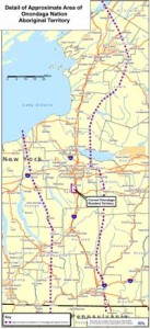
Unearthing the Land: A Traveler’s Guide to Onondaga Nation Historical Maps
To truly comprehend the ancestral heartland of the Onondaga Nation, one must look beyond contemporary GPS coordinates and delve into the intricate narratives woven across their historical maps. These aren’t merely ancient parchment or digital files; they are living documents, portals to a deep understanding of sovereignty, sacred geography, and the enduring spirit of the Onondaga people. For the discerning traveler seeking more than just scenic vistas, engaging with these maps offers an unparalleled journey into the very soul of a nation – a journey that transforms mere landscapes into a profound cultural tapestry.
The "place" we are reviewing here isn’t a single museum exhibit or archive, but rather the experience of connecting with the Onondaga Nation’s ancestral and contemporary lands through the lens of their historical cartography. This immersive exploration invites travelers to see New York’s Finger Lakes region, particularly the area around modern-day Syracuse, not just as a picturesque destination, but as the enduring territory of the Haudenosaunee (Iroquois) Confederacy’s Central Fire.
The Onondaga Nation: Keepers of the Central Fire

Before examining the maps, it’s crucial to understand the Onondaga Nation’s pivotal role. As one of the original five (later six) nations of the Haudenosaunee Confederacy, they hold the sacred responsibility of "Keepers of the Central Fire," symbolizing their central geographic and political position within the Confederacy. Their lands, encompassing what is now much of Central New York, were not just territory but a living entity, managed with profound respect and a holistic understanding of interconnectedness. This deep relationship with the land is precisely what their historical maps reveal.
Beyond Borders: What Onondaga Maps Reveal
Engaging with Onondaga historical maps is to undertake a masterclass in Indigenous land stewardship, political negotiation, and cultural resilience. These maps come in various forms, from early European attempts to delineate Indigenous territories to Indigenous-created conceptual maps like wampum belts, which served as mnemonic devices for treaties and land agreements.
-
Sovereignty and Political Landscape: Early colonial maps often show attempts to "claim" or divide Onondaga territory, yet even these often begrudgingly acknowledge the Onondaga’s control over vast areas. More importantly, Indigenous perspectives, often interpreted through wampum belts, illustrate a different kind of map – one based on shared understanding, reciprocal agreements, and spheres of influence rather than rigid, surveyed lines. The "Dish With One Spoon" wampum, for instance, represents a conceptual map of shared hunting grounds and resources, underscoring a philosophy of common stewardship rather than exclusive ownership. To experience this is to grasp the profound difference between Western and Indigenous concepts of land tenure.
-

Sacred Geography and Cultural Sites: Many historical references and some early ethnographic maps highlight the spiritual significance of specific locations within Onondaga territory. These might include council fire sites, ancient burial grounds, sacred springs, and places of ceremonial importance. For the traveler, this offers an opportunity to understand the landscape not just geographically, but spiritually. While many of these sites are not publicly accessible out of respect for their sanctity, learning about their existence transforms a generic forest into a hallowed ground, a mere hill into a place of ancient ceremony. This deepens appreciation for the Onondaga’s ongoing efforts to protect and revitalize these sacred spaces.
-
Resource Management and Traditional Pathways: Onondaga historical maps, or the accounts from which they are drawn, detail traditional hunting grounds, fishing locations (especially along Onondaga Lake and its tributaries), agricultural fields (corn, beans, squash – the "Three Sisters"), and vital trade routes. These routes, often following natural contours like river valleys and ridgelines, illustrate a sophisticated understanding of the land’s resources and efficient travel. Tracing these ancient pathways, even conceptually on a modern road map, allows one to appreciate the ingenuity and sustainability of Onondaga life before widespread European settlement. It highlights how the Onondaga lived with the land, not just on it.
-

The Impact of Colonialism and Treaties: As European settlement advanced, maps began to tell a more somber story. Successive treaties, often unilaterally broken or misunderstood, dramatically shrunk Onondaga territory. Maps from the 18th and 19th centuries visually represent this encroachment, showing the reduction of vast ancestral lands to the comparatively small Onondaga Nation Reservation of today. These maps are powerful historical documents that illustrate the immense pressure faced by the Onondaga and their enduring struggle for land rights and self-determination. Confronting these maps is a stark reminder of the historical injustices and the ongoing work of reconciliation.

Where to Encounter These Maps (and Their Stories):
While a single "Onondaga Nation Historical Map Museum" doesn’t exist, the experience of engaging with these maps is multifaceted and accessible through several key institutions and approaches:
- Onondaga Nation Archives: The most direct and authentic source, though access for general travelers may be limited and requires respectful inquiry. This is where the Onondaga Nation preserves its own records, wampum belts, and historical documents. Engaging with the Onondaga Nation directly, perhaps through their website or cultural liaisons, offers the most profound and authentic understanding.
- Syracuse University Special Collections Research Center: Home to extensive collections related to Haudenosaunee history, including maps, manuscripts, and ethnographic materials. This is a vital academic resource for researchers and serious history enthusiasts. Their collections often include early colonial maps depicting Onondaga territory and interactions.
- New York State Museum (Albany): Features significant exhibits on Haudenosaunee history and culture, often including maps and artifacts that contextualize the Onondaga’s place within the broader Confederacy. Their interpretations are often well-researched and accessible.
- Local Historical Societies (e.g., Onondaga Historical Association in Syracuse): These institutions frequently hold local maps, land deeds, and historical documents that show the evolution of the landscape and the impact of settlement on Onondaga lands. They offer a localized perspective on the broader historical narrative.
- Online Digital Archives: Many universities and libraries have digitized their collections, making a wealth of historical maps accessible from anywhere. Websites like the David Rumsey Map Collection or the Library of Congress often feature early maps of New York that delineate or refer to Onondaga territory. This is an excellent starting point for pre-trip research.
The Traveler’s Immersion: A Deeper Perspective
Engaging with Onondaga Nation historical maps is not a passive activity. It requires an open mind, a willingness to learn, and a commitment to responsible tourism.
- Pre-Trip Research: Before visiting Central New York, dedicate time to exploring online archives. Understand the names of key historical figures, treaties, and significant geographical features. This foundational knowledge will enrich your on-the-ground experience immeasurably.
- Visit with Respect: If the opportunity arises to visit the Onondaga Nation Reservation (which typically requires an invitation or participation in a specific event), approach with profound respect for their sovereignty and cultural protocols. Support Onondaga-owned businesses and cultural initiatives where possible.
- Contextualize the Landscape: As you drive through Syracuse and the surrounding areas, constantly refer back to what you’ve learned from the maps. See Onondaga Lake not just as a body of water, but as a historically vital resource and a modern-day site of environmental struggle and Indigenous-led cleanup efforts. View the hills and valleys as ancient pathways and sacred sites, not just scenic backdrops.
- Seek Onondaga Voices: The most authentic interpretation of these maps and the stories they tell comes directly from the Onondaga people. Look for opportunities to attend public lectures, cultural events, or exhibitions where Onondaga Nation members share their history and perspectives. Their oral traditions and interpretations breathe life into the cartographic data.
- Reflect and Connect: The ultimate "review" of this experience is the transformation of your own perspective. You will leave with a far deeper appreciation for the complex history of the land, the enduring resilience of the Onondaga Nation, and the power of maps to tell stories that transcend mere geography. You’ll see the landscape not just as a physical space, but as a repository of memory, struggle, and survival.
Conclusion: A Journey Beyond the Horizon
To review the "location" related to Onondaga Nation historical maps is to review an entire worldview. It is an invitation to step beyond the superficial and engage with a living history that continues to shape the present. These maps are not relics of a bygone era; they are vital tools for understanding the Onondaga Nation’s continuous fight for self-determination, their deep spiritual connection to their ancestral lands, and their ongoing role as environmental stewards.
For the traveler seeking an experience that challenges, educates, and inspires, delving into the historical maps of the Onondaga Nation offers an unforgettable journey. It’s a journey not just across physical space, but through layers of time, culture, and profound human resilience. It is an essential pilgrimage for anyone wishing to truly understand the heart of New York State and the enduring legacy of its first peoples. Prepare to have your perceptions of land, history, and sovereignty irrevocably transformed.
